You are here: Home > Network List > TA - USArray Transportable Network (new EarthScope stations) Stations List
> Station I30A Oacoma, SD, USA > Earthquake Result Viewer
I30A Oacoma, SD, USA - Earthquake Result Viewer
| Earthquake location: |
Near East Coast Of Honshu, Japan |
| Earthquake latitude/longitude: |
39.1/142.3 |
| Earthquake time(UTC): |
2011/03/11 (070) 12:15:45 GMT |
| Earthquake Depth: |
50 km |
| Earthquake Magnitude: |
5.8 MB |
| Earthquake Catalog/Contributor: |
WHDF/NEIC |
|
| Network: |
TA USArray Transportable Network (new EarthScope stations) |
| Station: |
I30A Oacoma, SD, USA |
| Lat/Lon: |
43.91 N/99.43 W |
| Elevation: |
549 m |
|
| Distance: |
80.4 deg |
| Az: |
40.192 deg |
| Baz: |
315.974 deg |
| Ray Param: |
0.04823237 |
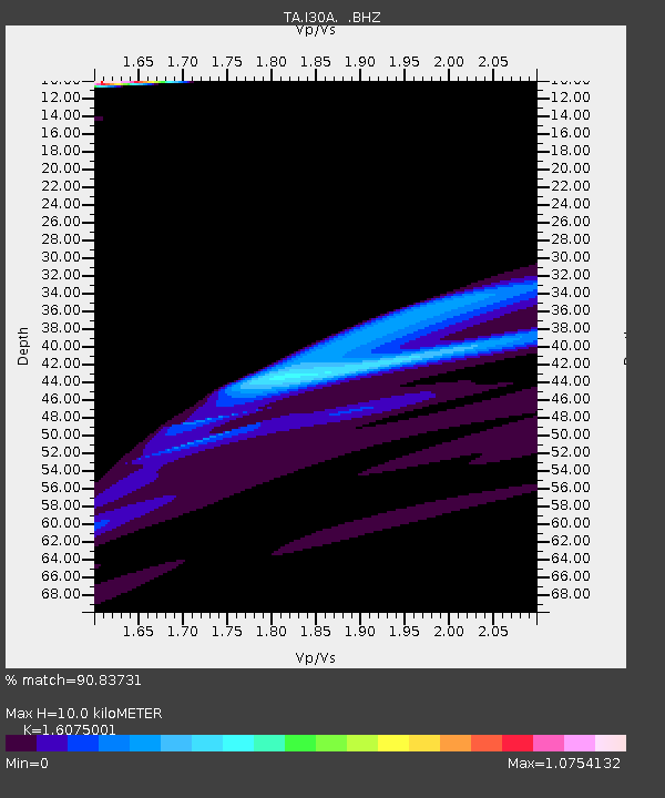
| Estimated Moho Depth: |
10.0 km |
| Estimated Crust Vp/Vs: |
1.61 |
| Assumed Crust Vp: |
6.53 km/s |
| Estimated Crust Vs: |
4.062 km/s |
| Estimated Crust Poisson's Ratio: |
0.18 |
|
| Radial Match: |
90.83731 % |
| Radial Bump: |
285 |
| Transverse Match: |
64.17605 % |
| Transverse Bump: |
266 |
| SOD ConfigId: |
356183 |
| Insert Time: |
2011-08-16 03:52:05.511 +0000 |
| GWidth: |
2.5 |
| Max Bumps: |
400 |
| Tol: |
0.001 |
|
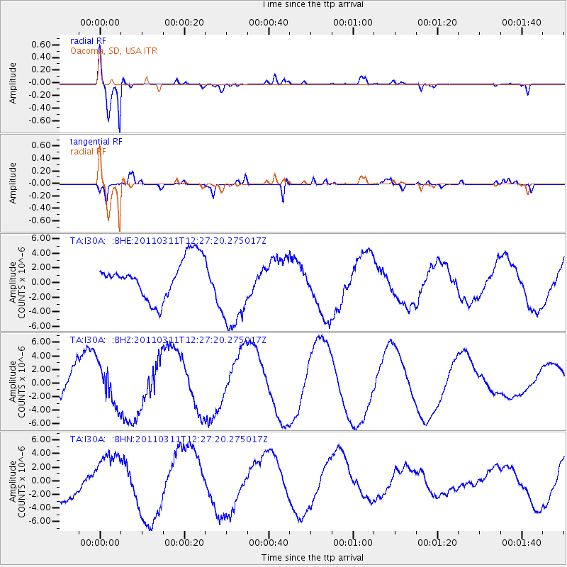
Signal To Noise
| Channel | StoN | STA | LTA |
| TA:I30A: :BHZ:20110311T12:27:20.275017Z | 1.3556412 | 2.845097E-6 | 2.0987095E-6 |
| TA:I30A: :BHN:20110311T12:27:20.275017Z | 1.915326 | 3.5668277E-6 | 1.8622562E-6 |
| TA:I30A: :BHE:20110311T12:27:20.275017Z | 2.1584313 | 5.7177363E-6 | 2.649024E-6 |
| Arrivals |
| Ps | 1.0 SECOND |
| PpPs | 3.9 SECOND |
| PsPs/PpSs | 4.8 SECOND |


