You are here: Home > Network List > II - Global Seismograph Network (GSN - IRIS/IDA) Stations List
> Station WRAB Tennant Creek, NT, Australia > Earthquake Result Viewer
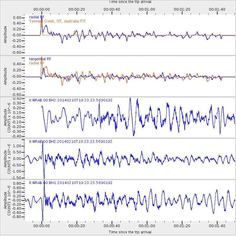
WRAB Tennant Creek, NT, Australia - Earthquake Result Viewer
*The percent match for this event was below the threshold and hence no stack was calculated.
| Earthquake location: |
Near East Coast Of Honshu, Japan |
| Earthquake latitude/longitude: |
34.2/140.0 |
| Earthquake time(UTC): |
2014/02/10 (041) 19:14:39 GMT |
| Earthquake Depth: |
95 km |
| Earthquake Magnitude: |
5.4 MW |
| Earthquake Catalog/Contributor: |
ISC/ISC |
|
| Network: |
II Global Seismograph Network (GSN - IRIS/IDA) |
| Station: |
WRAB Tennant Creek, NT, Australia |
| Lat/Lon: |
19.93 S/134.36 E |
| Elevation: |
366 m |
|
| Distance: |
54.1 deg |
| Az: |
186.587 deg |
| Baz: |
5.804 deg |
| Ray Param: |
$rayparam |
*The percent match for this event was below the threshold and hence was not used in the summary stack. |
|
| Radial Match: |
54.274086 % |
| Radial Bump: |
400 |
| Transverse Match: |
62.58963 % |
| Transverse Bump: |
400 |
| SOD ConfigId: |
3390531 |
| Insert Time: |
2019-04-10 07:31:20.729 +0000 |
| GWidth: |
2.5 |
| Max Bumps: |
400 |
| Tol: |
0.001 |
|
Signal To Noise
| Channel | StoN | STA | LTA |
| II:WRAB:00:BHZ:20140210T19:23:23.569019Z | 2.4180396 | 5.4205753E-7 | 2.2417231E-7 |
| II:WRAB:00:BH1:20140210T19:23:23.569019Z | 1.8570167 | 3.3139352E-7 | 1.784548E-7 |
| II:WRAB:00:BH2:20140210T19:23:23.569019Z | 0.9263477 | 1.193986E-7 | 1.288918E-7 |
| Arrivals |
| Ps | |
| PpPs | |
| PsPs/PpSs | |


