You are here: Home > Network List > TA - USArray Transportable Network (new EarthScope stations) Stations List
> Station 336A Riesel, TX, USA > Earthquake Result Viewer
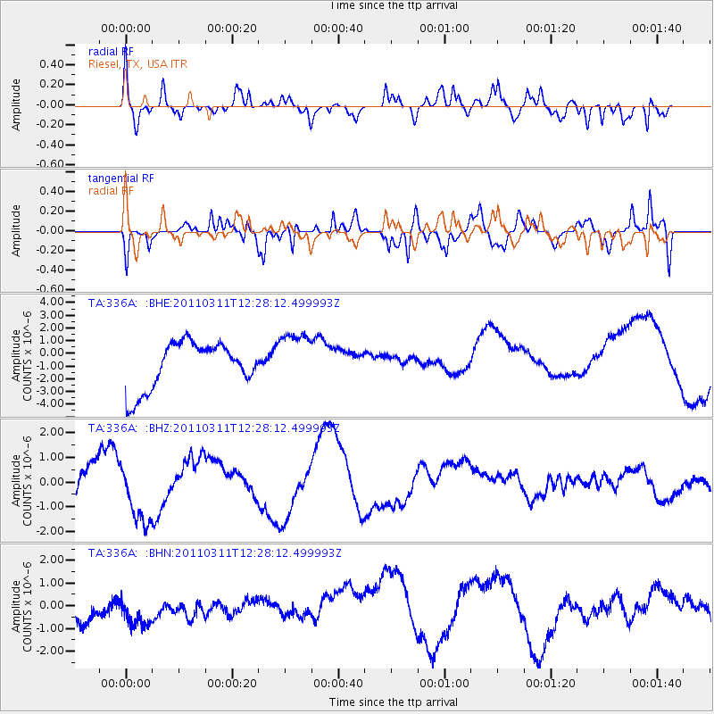
336A Riesel, TX, USA - Earthquake Result Viewer
*The percent match for this event was below the threshold and hence no stack was calculated.
| Earthquake location: |
Near East Coast Of Honshu, Japan |
| Earthquake latitude/longitude: |
39.1/142.3 |
| Earthquake time(UTC): |
2011/03/11 (070) 12:15:45 GMT |
| Earthquake Depth: |
50 km |
| Earthquake Magnitude: |
5.8 MB |
| Earthquake Catalog/Contributor: |
WHDF/NEIC |
|
| Network: |
TA USArray Transportable Network (new EarthScope stations) |
| Station: |
336A Riesel, TX, USA |
| Lat/Lon: |
31.39 N/96.84 W |
| Elevation: |
140 m |
|
| Distance: |
90.9 deg |
| Az: |
47.222 deg |
| Baz: |
318.089 deg |
| Ray Param: |
$rayparam |
*The percent match for this event was below the threshold and hence was not used in the summary stack. |
|
| Radial Match: |
61.23957 % |
| Radial Bump: |
400 |
| Transverse Match: |
60.89379 % |
| Transverse Bump: |
345 |
| SOD ConfigId: |
356183 |
| Insert Time: |
2011-08-16 04:02:50.020 +0000 |
| GWidth: |
2.5 |
| Max Bumps: |
400 |
| Tol: |
0.001 |
|
Signal To Noise
| Channel | StoN | STA | LTA |
| TA:336A: :BHZ:20110311T12:28:12.499993Z | 1.033273 | 1.1059823E-6 | 1.070368E-6 |
| TA:336A: :BHN:20110311T12:28:12.499993Z | 1.0716136 | 8.8551917E-7 | 8.2634193E-7 |
| TA:336A: :BHE:20110311T12:28:12.499993Z | 1.1818941 | 2.1600072E-6 | 1.827581E-6 |
| Arrivals |
| Ps | |
| PpPs | |
| PsPs/PpSs | |


