You are here: Home > Network List > TA - USArray Transportable Network (new EarthScope stations) Stations List
> Station N35A Tabor, IA, USA > Earthquake Result Viewer
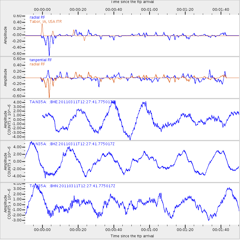
N35A Tabor, IA, USA - Earthquake Result Viewer
*The percent match for this event was below the threshold and hence no stack was calculated.
| Earthquake location: |
Near East Coast Of Honshu, Japan |
| Earthquake latitude/longitude: |
39.1/142.3 |
| Earthquake time(UTC): |
2011/03/11 (070) 12:15:45 GMT |
| Earthquake Depth: |
50 km |
| Earthquake Magnitude: |
5.8 MB |
| Earthquake Catalog/Contributor: |
WHDF/NEIC |
|
| Network: |
TA USArray Transportable Network (new EarthScope stations) |
| Station: |
N35A Tabor, IA, USA |
| Lat/Lon: |
40.86 N/95.64 W |
| Elevation: |
353 m |
|
| Distance: |
84.5 deg |
| Az: |
40.204 deg |
| Baz: |
318.518 deg |
| Ray Param: |
$rayparam |
*The percent match for this event was below the threshold and hence was not used in the summary stack. |
|
| Radial Match: |
89.87749 % |
| Radial Bump: |
372 |
| Transverse Match: |
45.83078 % |
| Transverse Bump: |
400 |
| SOD ConfigId: |
356183 |
| Insert Time: |
2011-08-16 04:06:46.805 +0000 |
| GWidth: |
2.5 |
| Max Bumps: |
400 |
| Tol: |
0.001 |
|
Signal To Noise
| Channel | StoN | STA | LTA |
| TA:N35A: :BHZ:20110311T12:27:41.775017Z | 1.1104985 | 3.1759257E-6 | 2.8599097E-6 |
| TA:N35A: :BHN:20110311T12:27:41.775017Z | 0.73524487 | 1.5483575E-6 | 2.1059072E-6 |
| TA:N35A: :BHE:20110311T12:27:41.775017Z | 1.3491802 | 2.1964506E-6 | 1.627989E-6 |
| Arrivals |
| Ps | |
| PpPs | |
| PsPs/PpSs | |


