You are here: Home > Network List > TA - USArray Transportable Network (new EarthScope stations) Stations List
> Station J01D Myrtle Point, OR, USA > Earthquake Result Viewer
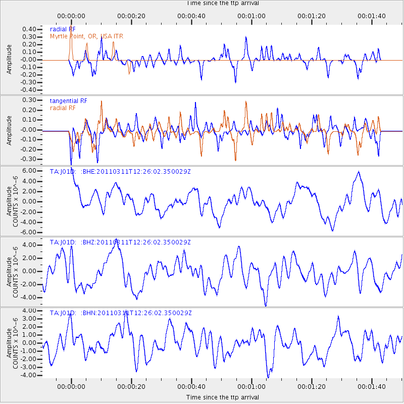
J01D Myrtle Point, OR, USA - Earthquake Result Viewer
*The percent match for this event was below the threshold and hence no stack was calculated.
| Earthquake location: |
Near East Coast Of Honshu, Japan |
| Earthquake latitude/longitude: |
39.1/142.3 |
| Earthquake time(UTC): |
2011/03/11 (070) 12:15:45 GMT |
| Earthquake Depth: |
50 km |
| Earthquake Magnitude: |
5.8 MB |
| Earthquake Catalog/Contributor: |
WHDF/NEIC |
|
| Network: |
TA USArray Transportable Network (new EarthScope stations) |
| Station: |
J01D Myrtle Point, OR, USA |
| Lat/Lon: |
43.16 N/123.93 W |
| Elevation: |
131 m |
|
| Distance: |
67.0 deg |
| Az: |
52.463 deg |
| Baz: |
302.496 deg |
| Ray Param: |
$rayparam |
*The percent match for this event was below the threshold and hence was not used in the summary stack. |
|
| Radial Match: |
66.53746 % |
| Radial Bump: |
371 |
| Transverse Match: |
64.47952 % |
| Transverse Bump: |
364 |
| SOD ConfigId: |
356183 |
| Insert Time: |
2011-08-16 04:15:51.421 +0000 |
| GWidth: |
2.5 |
| Max Bumps: |
400 |
| Tol: |
0.001 |
|
Signal To Noise
| Channel | StoN | STA | LTA |
| TA:J01D: :BHZ:20110311T12:26:02.350029Z | 1.5793228 | 2.569838E-6 | 1.6271771E-6 |
| TA:J01D: :BHN:20110311T12:26:02.350029Z | 1.292006 | 2.3929686E-6 | 1.8521342E-6 |
| TA:J01D: :BHE:20110311T12:26:02.350029Z | 1.2300296 | 2.4800404E-6 | 2.0162445E-6 |
| Arrivals |
| Ps | |
| PpPs | |
| PsPs/PpSs | |


