You are here: Home > Network List > TA - USArray Transportable Network (new EarthScope stations) Stations List
> Station D35A Remer, MN, USA > Earthquake Result Viewer
D35A Remer, MN, USA - Earthquake Result Viewer
| Earthquake location: |
Near East Coast Of Honshu, Japan |
| Earthquake latitude/longitude: |
39.1/142.3 |
| Earthquake time(UTC): |
2011/03/11 (070) 12:15:45 GMT |
| Earthquake Depth: |
50 km |
| Earthquake Magnitude: |
5.8 MB |
| Earthquake Catalog/Contributor: |
WHDF/NEIC |
|
| Network: |
TA USArray Transportable Network (new EarthScope stations) |
| Station: |
D35A Remer, MN, USA |
| Lat/Lon: |
47.08 N/94.05 W |
| Elevation: |
427 m |
|
| Distance: |
80.6 deg |
| Az: |
35.2 deg |
| Baz: |
318.97 deg |
| Ray Param: |
0.04808197 |
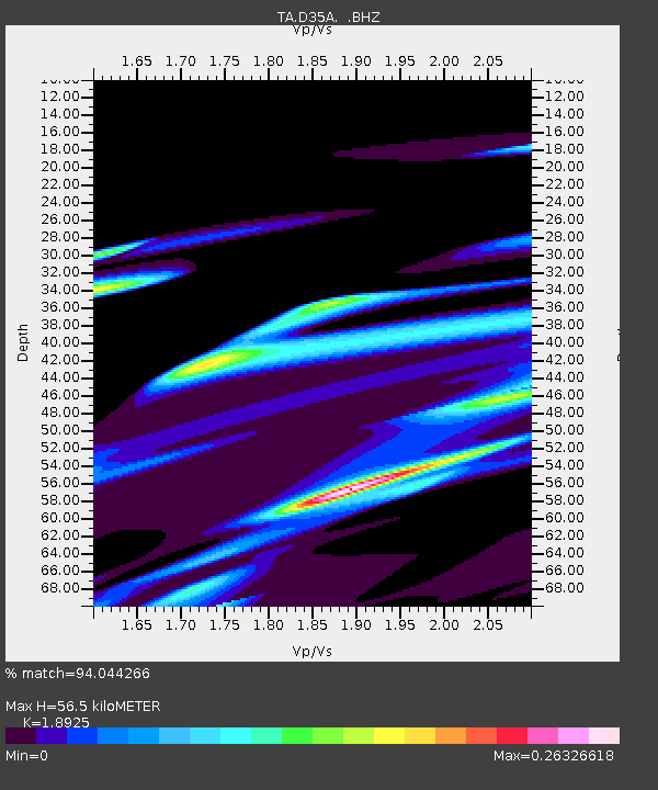
| Estimated Moho Depth: |
56.5 km |
| Estimated Crust Vp/Vs: |
1.89 |
| Assumed Crust Vp: |
6.419 km/s |
| Estimated Crust Vs: |
3.392 km/s |
| Estimated Crust Poisson's Ratio: |
0.31 |
|
| Radial Match: |
94.044266 % |
| Radial Bump: |
318 |
| Transverse Match: |
71.300446 % |
| Transverse Bump: |
336 |
| SOD ConfigId: |
356183 |
| Insert Time: |
2011-08-16 04:19:44.359 +0000 |
| GWidth: |
2.5 |
| Max Bumps: |
400 |
| Tol: |
0.001 |
|
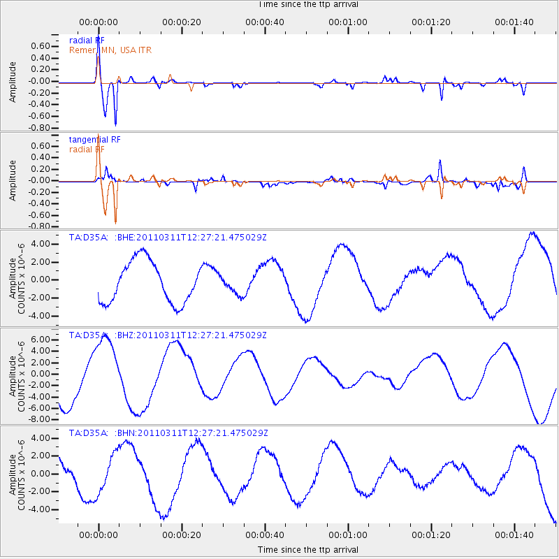
Signal To Noise
| Channel | StoN | STA | LTA |
| TA:D35A: :BHZ:20110311T12:27:21.475029Z | 1.5701904 | 6.322827E-6 | 4.02679E-6 |
| TA:D35A: :BHN:20110311T12:27:21.475029Z | 1.3730764 | 2.169084E-6 | 1.5797256E-6 |
| TA:D35A: :BHE:20110311T12:27:21.475029Z | 0.44920358 | 1.0179378E-6 | 2.2660947E-6 |
| Arrivals |
| Ps | 8.1 SECOND |
| PpPs | 25 SECOND |
| PsPs/PpSs | 33 SECOND |


