You are here: Home > Network List > TA - USArray Transportable Network (new EarthScope stations) Stations List
> Station M36A Felix, Anita, IA, USA > Earthquake Result Viewer
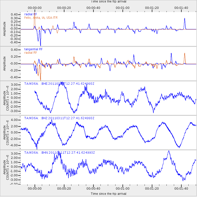
M36A Felix, Anita, IA, USA - Earthquake Result Viewer
*The percent match for this event was below the threshold and hence no stack was calculated.
| Earthquake location: |
Near East Coast Of Honshu, Japan |
| Earthquake latitude/longitude: |
39.1/142.3 |
| Earthquake time(UTC): |
2011/03/11 (070) 12:15:45 GMT |
| Earthquake Depth: |
50 km |
| Earthquake Magnitude: |
5.8 MB |
| Earthquake Catalog/Contributor: |
WHDF/NEIC |
|
| Network: |
TA USArray Transportable Network (new EarthScope stations) |
| Station: |
M36A Felix, Anita, IA, USA |
| Lat/Lon: |
41.45 N/94.80 W |
| Elevation: |
430 m |
|
| Distance: |
84.5 deg |
| Az: |
39.333 deg |
| Baz: |
318.985 deg |
| Ray Param: |
$rayparam |
*The percent match for this event was below the threshold and hence was not used in the summary stack. |
|
| Radial Match: |
82.743744 % |
| Radial Bump: |
386 |
| Transverse Match: |
36.774414 % |
| Transverse Bump: |
400 |
| SOD ConfigId: |
356183 |
| Insert Time: |
2011-08-16 04:29:56.211 +0000 |
| GWidth: |
2.5 |
| Max Bumps: |
400 |
| Tol: |
0.001 |
|
Signal To Noise
| Channel | StoN | STA | LTA |
| TA:M36A: :BHZ:20110311T12:27:41.624993Z | 3.384702 | 3.3477843E-6 | 9.890928E-7 |
| TA:M36A: :BHN:20110311T12:27:41.624993Z | 1.7850927 | 1.3569154E-6 | 7.6013725E-7 |
| TA:M36A: :BHE:20110311T12:27:41.624993Z | 0.6837719 | 1.4235337E-6 | 2.0818838E-6 |
| Arrivals |
| Ps | |
| PpPs | |
| PsPs/PpSs | |


