You are here: Home > Network List > TA - USArray Transportable Network (new EarthScope stations) Stations List
> Station 242A Grayson, LA, USA > Earthquake Result Viewer
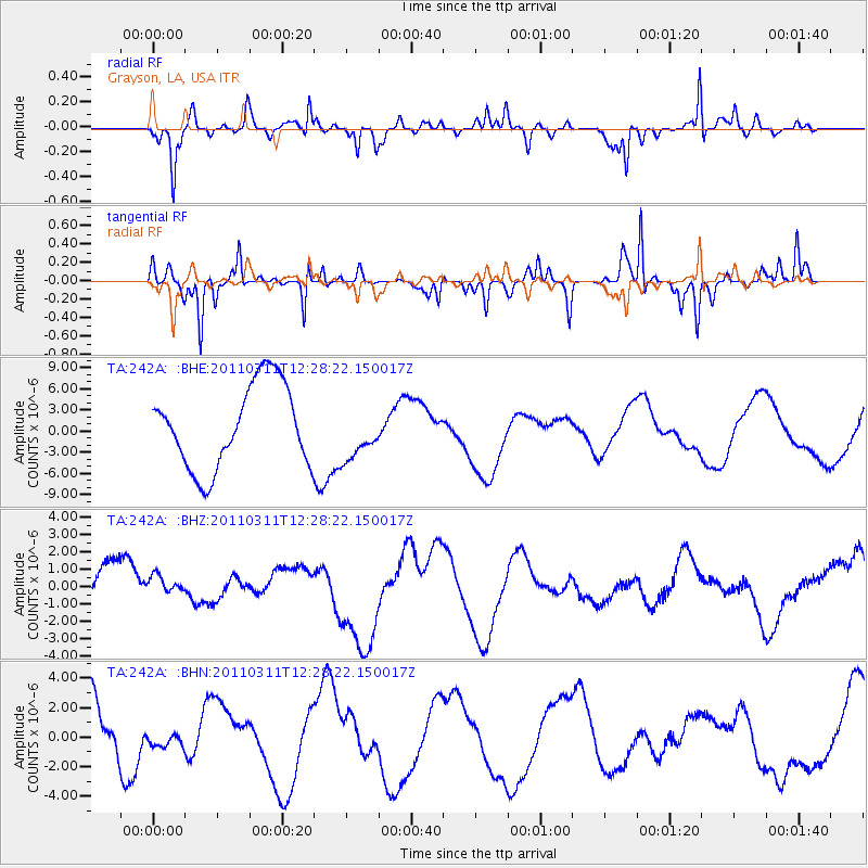
242A Grayson, LA, USA - Earthquake Result Viewer
*The percent match for this event was below the threshold and hence no stack was calculated.
| Earthquake location: |
Near East Coast Of Honshu, Japan |
| Earthquake latitude/longitude: |
39.1/142.3 |
| Earthquake time(UTC): |
2011/03/11 (070) 12:15:45 GMT |
| Earthquake Depth: |
50 km |
| Earthquake Magnitude: |
5.8 MB |
| Earthquake Catalog/Contributor: |
WHDF/NEIC |
|
| Network: |
TA USArray Transportable Network (new EarthScope stations) |
| Station: |
242A Grayson, LA, USA |
| Lat/Lon: |
32.06 N/92.15 W |
| Elevation: |
57 m |
|
| Distance: |
93.0 deg |
| Az: |
43.748 deg |
| Baz: |
320.666 deg |
| Ray Param: |
$rayparam |
*The percent match for this event was below the threshold and hence was not used in the summary stack. |
|
| Radial Match: |
65.96253 % |
| Radial Bump: |
284 |
| Transverse Match: |
55.126656 % |
| Transverse Bump: |
194 |
| SOD ConfigId: |
356183 |
| Insert Time: |
2011-08-16 04:35:42.811 +0000 |
| GWidth: |
2.5 |
| Max Bumps: |
400 |
| Tol: |
0.001 |
|
Signal To Noise
| Channel | StoN | STA | LTA |
| TA:242A: :BHZ:20110311T12:28:22.150017Z | 1.016216 | 1.0463962E-6 | 1.0296985E-6 |
| TA:242A: :BHN:20110311T12:28:22.150017Z | 0.16156547 | 3.7723433E-7 | 2.3348698E-6 |
| TA:242A: :BHE:20110311T12:28:22.150017Z | 0.6289078 | 3.6836914E-6 | 5.857284E-6 |
| Arrivals |
| Ps | |
| PpPs | |
| PsPs/PpSs | |


