You are here: Home > Network List > TA - USArray Transportable Network (new EarthScope stations) Stations List
> Station J01E Myrtle Point, OR, USA > Earthquake Result Viewer
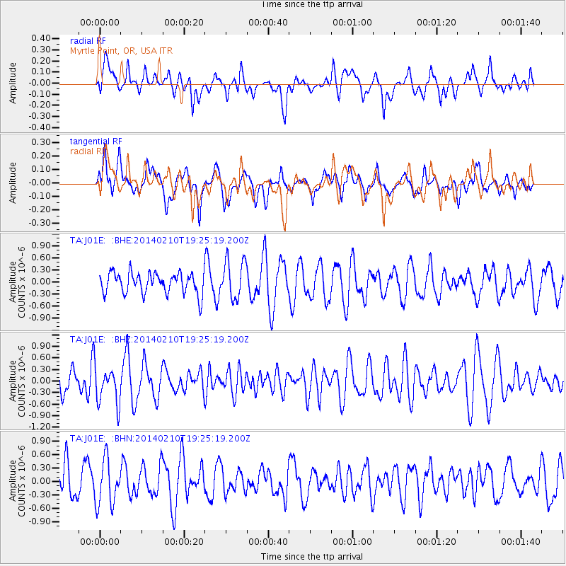
J01E Myrtle Point, OR, USA - Earthquake Result Viewer
*The percent match for this event was below the threshold and hence no stack was calculated.
| Earthquake location: |
Near East Coast Of Honshu, Japan |
| Earthquake latitude/longitude: |
34.2/140.0 |
| Earthquake time(UTC): |
2014/02/10 (041) 19:14:39 GMT |
| Earthquake Depth: |
95 km |
| Earthquake Magnitude: |
5.4 MW |
| Earthquake Catalog/Contributor: |
ISC/ISC |
|
| Network: |
TA USArray Transportable Network (new EarthScope stations) |
| Station: |
J01E Myrtle Point, OR, USA |
| Lat/Lon: |
43.16 N/123.93 W |
| Elevation: |
128 m |
|
| Distance: |
71.5 deg |
| Az: |
50.105 deg |
| Baz: |
299.595 deg |
| Ray Param: |
$rayparam |
*The percent match for this event was below the threshold and hence was not used in the summary stack. |
|
| Radial Match: |
45.821022 % |
| Radial Bump: |
400 |
| Transverse Match: |
54.468594 % |
| Transverse Bump: |
400 |
| SOD ConfigId: |
3390531 |
| Insert Time: |
2019-04-10 07:33:43.063 +0000 |
| GWidth: |
2.5 |
| Max Bumps: |
400 |
| Tol: |
0.001 |
|
Signal To Noise
| Channel | StoN | STA | LTA |
| TA:J01E: :BHZ:20140210T19:25:19.200Z | 1.7876048 | 4.5956656E-7 | 2.570851E-7 |
| TA:J01E: :BHN:20140210T19:25:19.200Z | 1.4868891 | 5.129799E-7 | 3.4500212E-7 |
| TA:J01E: :BHE:20140210T19:25:19.200Z | 1.8954779 | 4.9319266E-7 | 2.6019438E-7 |
| Arrivals |
| Ps | |
| PpPs | |
| PsPs/PpSs | |


