You are here: Home > Network List > TA - USArray Transportable Network (new EarthScope stations) Stations List
> Station R11A Troy Canyon, Currant, NV, USA > Earthquake Result Viewer
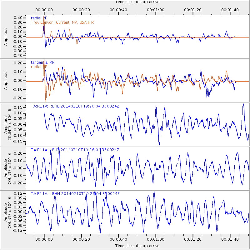
R11A Troy Canyon, Currant, NV, USA - Earthquake Result Viewer
*The percent match for this event was below the threshold and hence no stack was calculated.
| Earthquake location: |
Near East Coast Of Honshu, Japan |
| Earthquake latitude/longitude: |
34.2/140.0 |
| Earthquake time(UTC): |
2014/02/10 (041) 19:14:39 GMT |
| Earthquake Depth: |
95 km |
| Earthquake Magnitude: |
5.4 MW |
| Earthquake Catalog/Contributor: |
ISC/ISC |
|
| Network: |
TA USArray Transportable Network (new EarthScope stations) |
| Station: |
R11A Troy Canyon, Currant, NV, USA |
| Lat/Lon: |
38.35 N/115.59 W |
| Elevation: |
1756 m |
|
| Distance: |
79.4 deg |
| Az: |
50.78 deg |
| Baz: |
305.203 deg |
| Ray Param: |
$rayparam |
*The percent match for this event was below the threshold and hence was not used in the summary stack. |
|
| Radial Match: |
54.911743 % |
| Radial Bump: |
400 |
| Transverse Match: |
51.707706 % |
| Transverse Bump: |
400 |
| SOD ConfigId: |
3390531 |
| Insert Time: |
2019-04-10 07:34:02.591 +0000 |
| GWidth: |
2.5 |
| Max Bumps: |
400 |
| Tol: |
0.001 |
|
Signal To Noise
| Channel | StoN | STA | LTA |
| TA:R11A: :BHZ:20140210T19:26:04.350024Z | 1.5284377 | 1.2373344E-7 | 8.095419E-8 |
| TA:R11A: :BHN:20140210T19:26:04.350024Z | 2.1901705 | 5.8718083E-8 | 2.6809822E-8 |
| TA:R11A: :BHE:20140210T19:26:04.350024Z | 0.758743 | 3.9207606E-8 | 5.1674427E-8 |
| Arrivals |
| Ps | |
| PpPs | |
| PsPs/PpSs | |


