You are here: Home > Network List > US - United States National Seismic Network Stations List
> Station AMTX Amarillo, Texas, USA > Earthquake Result Viewer
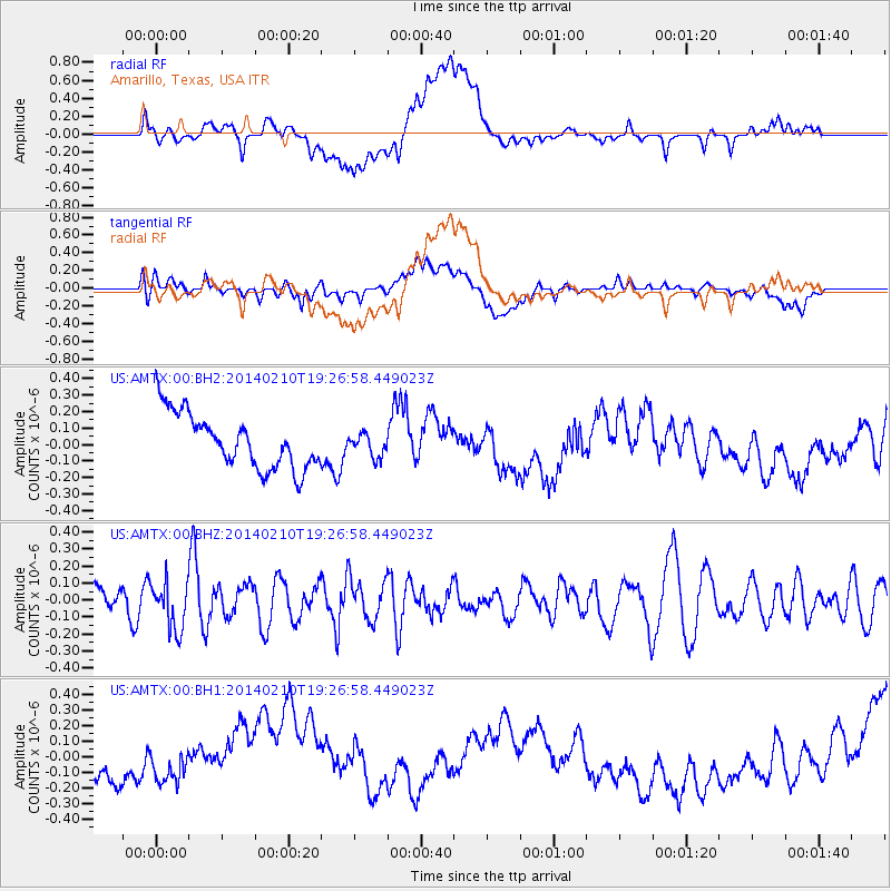
AMTX Amarillo, Texas, USA - Earthquake Result Viewer
*The percent match for this event was below the threshold and hence no stack was calculated.
| Earthquake location: |
Near East Coast Of Honshu, Japan |
| Earthquake latitude/longitude: |
34.2/140.0 |
| Earthquake time(UTC): |
2014/02/10 (041) 19:14:39 GMT |
| Earthquake Depth: |
95 km |
| Earthquake Magnitude: |
5.4 MW |
| Earthquake Catalog/Contributor: |
ISC/ISC |
|
| Network: |
US United States National Seismic Network |
| Station: |
AMTX Amarillo, Texas, USA |
| Lat/Lon: |
34.53 N/101.41 W |
| Elevation: |
1010 m |
|
| Distance: |
90.7 deg |
| Az: |
46.481 deg |
| Baz: |
313.248 deg |
| Ray Param: |
$rayparam |
*The percent match for this event was below the threshold and hence was not used in the summary stack. |
|
| Radial Match: |
27.769205 % |
| Radial Bump: |
400 |
| Transverse Match: |
25.747717 % |
| Transverse Bump: |
400 |
| SOD ConfigId: |
3390531 |
| Insert Time: |
2019-04-10 07:34:32.572 +0000 |
| GWidth: |
2.5 |
| Max Bumps: |
400 |
| Tol: |
0.001 |
|
Signal To Noise
| Channel | StoN | STA | LTA |
| US:AMTX:00:BHZ:20140210T19:26:58.449023Z | 1.2965235 | 1.3819461E-7 | 1.06588594E-7 |
| US:AMTX:00:BH1:20140210T19:26:58.449023Z | 0.8120463 | 7.533699E-8 | 9.277426E-8 |
| US:AMTX:00:BH2:20140210T19:26:58.449023Z | 1.0060817 | 1.448936E-7 | 1.4401773E-7 |
| Arrivals |
| Ps | |
| PpPs | |
| PsPs/PpSs | |


