You are here: Home > Network List > TA - USArray Transportable Network (new EarthScope stations) Stations List
> Station P32A Huiting Farm, Downs, KS, USA > Earthquake Result Viewer
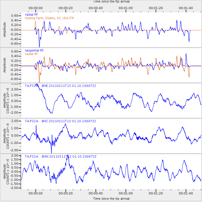
P32A Huiting Farm, Downs, KS, USA - Earthquake Result Viewer
*The percent match for this event was below the threshold and hence no stack was calculated.
| Earthquake location: |
Near East Coast Of Honshu, Japan |
| Earthquake latitude/longitude: |
36.1/141.6 |
| Earthquake time(UTC): |
2011/03/11 (070) 12:49:02 GMT |
| Earthquake Depth: |
35 km |
| Earthquake Magnitude: |
5.6 MB |
| Earthquake Catalog/Contributor: |
WHDF/NEIC |
|
| Network: |
TA USArray Transportable Network (new EarthScope stations) |
| Station: |
P32A Huiting Farm, Downs, KS, USA |
| Lat/Lon: |
39.62 N/98.60 W |
| Elevation: |
524 m |
|
| Distance: |
86.4 deg |
| Az: |
42.188 deg |
| Baz: |
315.271 deg |
| Ray Param: |
$rayparam |
*The percent match for this event was below the threshold and hence was not used in the summary stack. |
|
| Radial Match: |
58.958305 % |
| Radial Bump: |
348 |
| Transverse Match: |
54.111115 % |
| Transverse Bump: |
327 |
| SOD ConfigId: |
356183 |
| Insert Time: |
2011-08-16 06:19:50.281 +0000 |
| GWidth: |
2.5 |
| Max Bumps: |
400 |
| Tol: |
0.001 |
|
Signal To Noise
| Channel | StoN | STA | LTA |
| TA:P32A: :BHZ:20110311T13:01:10.299973Z | 1.1388916 | 6.8676457E-7 | 6.030114E-7 |
| TA:P32A: :BHN:20110311T13:01:10.299973Z | 1.3617045 | 1.4400363E-6 | 1.0575247E-6 |
| TA:P32A: :BHE:20110311T13:01:10.299973Z | 0.50145894 | 6.9451875E-7 | 1.3849962E-6 |
| Arrivals |
| Ps | |
| PpPs | |
| PsPs/PpSs | |


