You are here: Home > Network List > TA - USArray Transportable Network (new EarthScope stations) Stations List
> Station Z35A Perchaven, Sanger, TX, USA > Earthquake Result Viewer
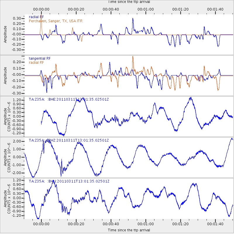
Z35A Perchaven, Sanger, TX, USA - Earthquake Result Viewer
*The percent match for this event was below the threshold and hence no stack was calculated.
| Earthquake location: |
Near East Coast Of Honshu, Japan |
| Earthquake latitude/longitude: |
36.1/141.6 |
| Earthquake time(UTC): |
2011/03/11 (070) 12:49:02 GMT |
| Earthquake Depth: |
35 km |
| Earthquake Magnitude: |
5.6 MB |
| Earthquake Catalog/Contributor: |
WHDF/NEIC |
|
| Network: |
TA USArray Transportable Network (new EarthScope stations) |
| Station: |
Z35A Perchaven, Sanger, TX, USA |
| Lat/Lon: |
33.33 N/97.25 W |
| Elevation: |
235 m |
|
| Distance: |
91.7 deg |
| Az: |
45.794 deg |
| Baz: |
316.13 deg |
| Ray Param: |
$rayparam |
*The percent match for this event was below the threshold and hence was not used in the summary stack. |
|
| Radial Match: |
60.09241 % |
| Radial Bump: |
400 |
| Transverse Match: |
59.470142 % |
| Transverse Bump: |
400 |
| SOD ConfigId: |
356183 |
| Insert Time: |
2011-08-16 06:24:06.473 +0000 |
| GWidth: |
2.5 |
| Max Bumps: |
400 |
| Tol: |
0.001 |
|
Signal To Noise
| Channel | StoN | STA | LTA |
| TA:Z35A: :BHZ:20110311T13:01:35.02501Z | 1.318784 | 1.5337233E-6 | 1.1629829E-6 |
| TA:Z35A: :BHN:20110311T13:01:35.02501Z | 1.2624681 | 8.0432295E-7 | 6.371036E-7 |
| TA:Z35A: :BHE:20110311T13:01:35.02501Z | 0.662297 | 5.475892E-7 | 8.2680305E-7 |
| Arrivals |
| Ps | |
| PpPs | |
| PsPs/PpSs | |


