You are here: Home > Network List > TA - USArray Transportable Network (new EarthScope stations) Stations List
> Station L33A Hoskins, NE, USA > Earthquake Result Viewer
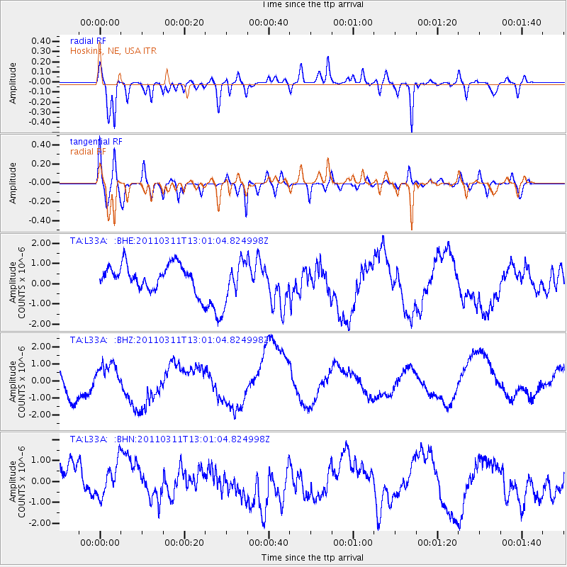
L33A Hoskins, NE, USA - Earthquake Result Viewer
*The percent match for this event was below the threshold and hence no stack was calculated.
| Earthquake location: |
Near East Coast Of Honshu, Japan |
| Earthquake latitude/longitude: |
36.1/141.6 |
| Earthquake time(UTC): |
2011/03/11 (070) 12:49:02 GMT |
| Earthquake Depth: |
35 km |
| Earthquake Magnitude: |
5.6 MB |
| Earthquake Catalog/Contributor: |
WHDF/NEIC |
|
| Network: |
TA USArray Transportable Network (new EarthScope stations) |
| Station: |
L33A Hoskins, NE, USA |
| Lat/Lon: |
42.17 N/97.27 W |
| Elevation: |
556 m |
|
| Distance: |
85.3 deg |
| Az: |
39.684 deg |
| Baz: |
315.958 deg |
| Ray Param: |
$rayparam |
*The percent match for this event was below the threshold and hence was not used in the summary stack. |
|
| Radial Match: |
60.240646 % |
| Radial Bump: |
400 |
| Transverse Match: |
41.869583 % |
| Transverse Bump: |
400 |
| SOD ConfigId: |
356183 |
| Insert Time: |
2011-08-16 06:36:45.536 +0000 |
| GWidth: |
2.5 |
| Max Bumps: |
400 |
| Tol: |
0.001 |
|
Signal To Noise
| Channel | StoN | STA | LTA |
| TA:L33A: :BHZ:20110311T13:01:04.824998Z | 0.74898434 | 8.5169773E-7 | 1.1371369E-6 |
| TA:L33A: :BHN:20110311T13:01:04.824998Z | 0.94773436 | 8.500278E-7 | 8.969051E-7 |
| TA:L33A: :BHE:20110311T13:01:04.824998Z | 1.5213678 | 9.5096E-7 | 6.250691E-7 |
| Arrivals |
| Ps | |
| PpPs | |
| PsPs/PpSs | |


