You are here: Home > Network List > TA - USArray Transportable Network (new EarthScope stations) Stations List
> Station P37A Lathrop, MO, USA > Earthquake Result Viewer
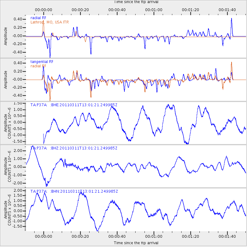
P37A Lathrop, MO, USA - Earthquake Result Viewer
*The percent match for this event was below the threshold and hence no stack was calculated.
| Earthquake location: |
Near East Coast Of Honshu, Japan |
| Earthquake latitude/longitude: |
36.1/141.6 |
| Earthquake time(UTC): |
2011/03/11 (070) 12:49:02 GMT |
| Earthquake Depth: |
35 km |
| Earthquake Magnitude: |
5.6 MB |
| Earthquake Catalog/Contributor: |
WHDF/NEIC |
|
| Network: |
TA USArray Transportable Network (new EarthScope stations) |
| Station: |
P37A Lathrop, MO, USA |
| Lat/Lon: |
39.59 N/94.35 W |
| Elevation: |
300 m |
|
| Distance: |
88.7 deg |
| Az: |
39.824 deg |
| Baz: |
317.871 deg |
| Ray Param: |
$rayparam |
*The percent match for this event was below the threshold and hence was not used in the summary stack. |
|
| Radial Match: |
71.41349 % |
| Radial Bump: |
321 |
| Transverse Match: |
60.80499 % |
| Transverse Bump: |
349 |
| SOD ConfigId: |
356183 |
| Insert Time: |
2011-08-16 06:51:02.956 +0000 |
| GWidth: |
2.5 |
| Max Bumps: |
400 |
| Tol: |
0.001 |
|
Signal To Noise
| Channel | StoN | STA | LTA |
| TA:P37A: :BHZ:20110311T13:01:21.249985Z | 1.1700464 | 1.7572172E-6 | 1.5018354E-6 |
| TA:P37A: :BHN:20110311T13:01:21.249985Z | 1.6727186 | 1.9238241E-6 | 1.1501182E-6 |
| TA:P37A: :BHE:20110311T13:01:21.249985Z | 0.40743563 | 2.1533312E-7 | 5.285083E-7 |
| Arrivals |
| Ps | |
| PpPs | |
| PsPs/PpSs | |


