You are here: Home > Network List > US - United States National Seismic Network Stations List
> Station HAWA Hanford, Washington, USA > Earthquake Result Viewer
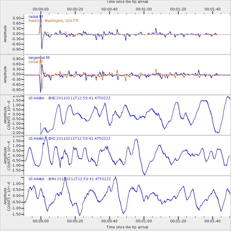
HAWA Hanford, Washington, USA - Earthquake Result Viewer
*The percent match for this event was below the threshold and hence no stack was calculated.
| Earthquake location: |
Near East Coast Of Honshu, Japan |
| Earthquake latitude/longitude: |
36.1/141.6 |
| Earthquake time(UTC): |
2011/03/11 (070) 12:49:02 GMT |
| Earthquake Depth: |
35 km |
| Earthquake Magnitude: |
5.6 MB |
| Earthquake Catalog/Contributor: |
WHDF/NEIC |
|
| Network: |
US United States National Seismic Network |
| Station: |
HAWA Hanford, Washington, USA |
| Lat/Lon: |
46.39 N/119.53 W |
| Elevation: |
364 m |
|
| Distance: |
70.3 deg |
| Az: |
46.594 deg |
| Baz: |
301.834 deg |
| Ray Param: |
$rayparam |
*The percent match for this event was below the threshold and hence was not used in the summary stack. |
|
| Radial Match: |
58.97914 % |
| Radial Bump: |
385 |
| Transverse Match: |
63.99812 % |
| Transverse Bump: |
363 |
| SOD ConfigId: |
356183 |
| Insert Time: |
2011-08-16 07:03:18.190 +0000 |
| GWidth: |
2.5 |
| Max Bumps: |
400 |
| Tol: |
0.001 |
|
Signal To Noise
| Channel | StoN | STA | LTA |
| US:HAWA: :BHZ:20110311T12:59:41.475022Z | 1.4180754 | 1.4082103E-6 | 9.930434E-7 |
| US:HAWA: :BHN:20110311T12:59:41.475022Z | 1.1587228 | 6.2456945E-7 | 5.3901545E-7 |
| US:HAWA: :BHE:20110311T12:59:41.475022Z | 0.8343794 | 8.1347133E-7 | 9.749418E-7 |
| Arrivals |
| Ps | |
| PpPs | |
| PsPs/PpSs | |


