You are here: Home > Network List > 2G - Testing of the effectiveness of incorporating seismic data in seismic hazard ass Stations List
> Station IUGFS Indiana Univ Geologic Field Station, Cardwell, MT > Earthquake Result Viewer
IUGFS Indiana Univ Geologic Field Station, Cardwell, MT - Earthquake Result Viewer
| Earthquake location: |
Kermadec Islands Region |
| Earthquake latitude/longitude: |
-29.2/-176.8 |
| Earthquake time(UTC): |
2014/02/10 (041) 21:49:48 GMT |
| Earthquake Depth: |
36 km |
| Earthquake Magnitude: |
5.0 MW |
| Earthquake Catalog/Contributor: |
ISC/ISC |
|
| Network: |
2G Testing of the effectiveness of incorporating seismic data in seismic hazard ass |
| Station: |
IUGFS Indiana Univ Geologic Field Station, Cardwell, MT |
| Lat/Lon: |
45.73 N/111.97 W |
| Elevation: |
1634 m |
|
| Distance: |
95.0 deg |
| Az: |
39.531 deg |
| Baz: |
232.601 deg |
| Ray Param: |
0.040895037 |
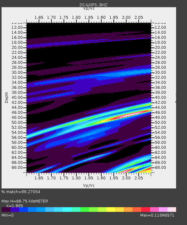
| Estimated Moho Depth: |
69.75 km |
| Estimated Crust Vp/Vs: |
1.99 |
| Assumed Crust Vp: |
6.35 km/s |
| Estimated Crust Vs: |
3.199 km/s |
| Estimated Crust Poisson's Ratio: |
0.33 |
|
| Radial Match: |
99.27054 % |
| Radial Bump: |
113 |
| Transverse Match: |
98.64829 % |
| Transverse Bump: |
191 |
| SOD ConfigId: |
3390531 |
| Insert Time: |
2019-04-10 07:37:04.666 +0000 |
| GWidth: |
2.5 |
| Max Bumps: |
400 |
| Tol: |
0.001 |
|

Signal To Noise
| Channel | StoN | STA | LTA |
| 2G:IUGFS: :BHZ:20140210T22:02:35.55001Z | 0.61410373 | 3.2256178E-8 | 5.252562E-8 |
| 2G:IUGFS: :BHN:20140210T22:02:35.55001Z | 0.6962509 | 4.3648097E-8 | 6.2690184E-8 |
| 2G:IUGFS: :BHE:20140210T22:02:35.55001Z | 2.2883773 | 8.269072E-9 | 3.6135086E-9 |
| Arrivals |
| Ps | 11 SECOND |
| PpPs | 32 SECOND |
| PsPs/PpSs | 43 SECOND |


