You are here: Home > Network List > TA - USArray Transportable Network (new EarthScope stations) Stations List
> Station C26A Wahner Farm, Parshall, ND, USA > Earthquake Result Viewer
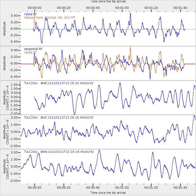
C26A Wahner Farm, Parshall, ND, USA - Earthquake Result Viewer
*The percent match for this event was below the threshold and hence no stack was calculated.
| Earthquake location: |
Near East Coast Of Honshu, Japan |
| Earthquake latitude/longitude: |
36.4/141.7 |
| Earthquake time(UTC): |
2011/03/11 (070) 13:16:51 GMT |
| Earthquake Depth: |
58 km |
| Earthquake Magnitude: |
5.6 MB |
| Earthquake Catalog/Contributor: |
WHDF/NEIC |
|
| Network: |
TA USArray Transportable Network (new EarthScope stations) |
| Station: |
C26A Wahner Farm, Parshall, ND, USA |
| Lat/Lon: |
47.83 N/102.10 W |
| Elevation: |
656 m |
|
| Distance: |
78.7 deg |
| Az: |
38.086 deg |
| Baz: |
312.37 deg |
| Ray Param: |
$rayparam |
*The percent match for this event was below the threshold and hence was not used in the summary stack. |
|
| Radial Match: |
61.74934 % |
| Radial Bump: |
400 |
| Transverse Match: |
51.5382 % |
| Transverse Bump: |
400 |
| SOD ConfigId: |
356183 |
| Insert Time: |
2011-08-16 09:10:44.049 +0000 |
| GWidth: |
2.5 |
| Max Bumps: |
400 |
| Tol: |
0.001 |
|
Signal To Noise
| Channel | StoN | STA | LTA |
| TA:C26A: :BHZ:20110311T13:28:16.400024Z | 0.51379997 | 3.4132867E-7 | 6.6432204E-7 |
| TA:C26A: :BHN:20110311T13:28:16.400024Z | 1.1328888 | 1.6292423E-6 | 1.4381308E-6 |
| TA:C26A: :BHE:20110311T13:28:16.400024Z | 0.8872721 | 5.4537895E-7 | 6.146693E-7 |
| Arrivals |
| Ps | |
| PpPs | |
| PsPs/PpSs | |


