You are here: Home > Network List > TA - USArray Transportable Network (new EarthScope stations) Stations List
> Station 533A Kerrville, TX, USA > Earthquake Result Viewer
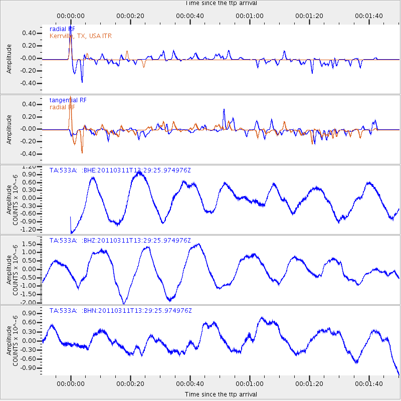
533A Kerrville, TX, USA - Earthquake Result Viewer
*The percent match for this event was below the threshold and hence no stack was calculated.
| Earthquake location: |
Near East Coast Of Honshu, Japan |
| Earthquake latitude/longitude: |
36.4/141.7 |
| Earthquake time(UTC): |
2011/03/11 (070) 13:16:51 GMT |
| Earthquake Depth: |
58 km |
| Earthquake Magnitude: |
5.6 MB |
| Earthquake Catalog/Contributor: |
WHDF/NEIC |
|
| Network: |
TA USArray Transportable Network (new EarthScope stations) |
| Station: |
533A Kerrville, TX, USA |
| Lat/Lon: |
30.07 N/99.04 W |
| Elevation: |
556 m |
|
| Distance: |
92.7 deg |
| Az: |
49.233 deg |
| Baz: |
315.157 deg |
| Ray Param: |
$rayparam |
*The percent match for this event was below the threshold and hence was not used in the summary stack. |
|
| Radial Match: |
66.506805 % |
| Radial Bump: |
400 |
| Transverse Match: |
42.675694 % |
| Transverse Bump: |
366 |
| SOD ConfigId: |
356183 |
| Insert Time: |
2011-08-16 09:16:56.698 +0000 |
| GWidth: |
2.5 |
| Max Bumps: |
400 |
| Tol: |
0.001 |
|
Signal To Noise
| Channel | StoN | STA | LTA |
| TA:533A: :BHZ:20110311T13:29:25.974976Z | 1.1047373 | 8.2219464E-7 | 7.442445E-7 |
| TA:533A: :BHN:20110311T13:29:25.974976Z | 0.27110434 | 1.8851519E-7 | 6.953603E-7 |
| TA:533A: :BHE:20110311T13:29:25.974976Z | 0.66449845 | 4.9398545E-7 | 7.4339596E-7 |
| Arrivals |
| Ps | |
| PpPs | |
| PsPs/PpSs | |


