You are here: Home > Network List > TA - USArray Transportable Network (new EarthScope stations) Stations List
> Station V35A Meyer Ranch, Chandler, OK, USA > Earthquake Result Viewer
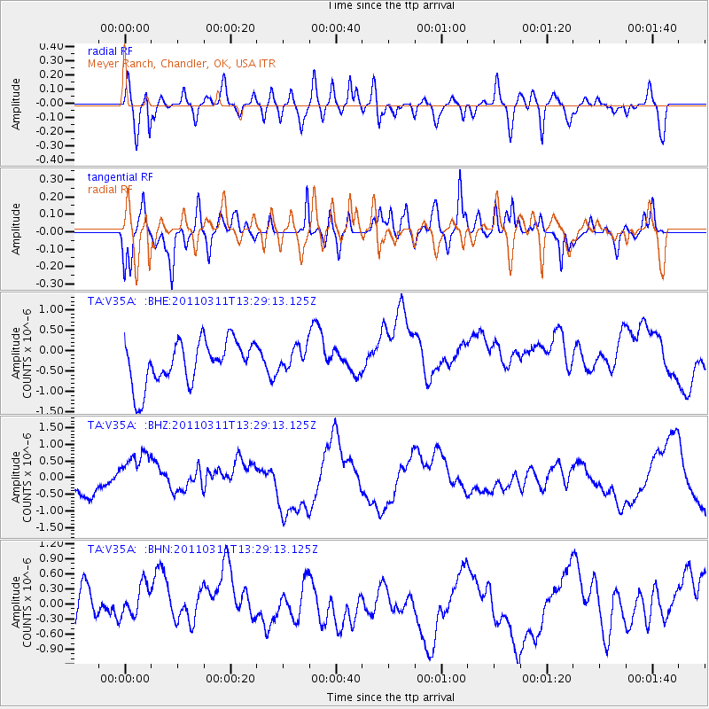
V35A Meyer Ranch, Chandler, OK, USA - Earthquake Result Viewer
*The percent match for this event was below the threshold and hence no stack was calculated.
| Earthquake location: |
Near East Coast Of Honshu, Japan |
| Earthquake latitude/longitude: |
36.4/141.7 |
| Earthquake time(UTC): |
2011/03/11 (070) 13:16:51 GMT |
| Earthquake Depth: |
58 km |
| Earthquake Magnitude: |
5.6 MB |
| Earthquake Catalog/Contributor: |
WHDF/NEIC |
|
| Network: |
TA USArray Transportable Network (new EarthScope stations) |
| Station: |
V35A Meyer Ranch, Chandler, OK, USA |
| Lat/Lon: |
35.76 N/96.84 W |
| Elevation: |
280 m |
|
| Distance: |
89.9 deg |
| Az: |
43.952 deg |
| Baz: |
316.469 deg |
| Ray Param: |
$rayparam |
*The percent match for this event was below the threshold and hence was not used in the summary stack. |
|
| Radial Match: |
54.67929 % |
| Radial Bump: |
400 |
| Transverse Match: |
51.10037 % |
| Transverse Bump: |
360 |
| SOD ConfigId: |
356183 |
| Insert Time: |
2011-08-16 09:22:02.003 +0000 |
| GWidth: |
2.5 |
| Max Bumps: |
400 |
| Tol: |
0.001 |
|
Signal To Noise
| Channel | StoN | STA | LTA |
| TA:V35A: :BHZ:20110311T13:29:13.125Z | 1.5371778 | 8.0246554E-7 | 5.220382E-7 |
| TA:V35A: :BHN:20110311T13:29:13.125Z | 0.8617353 | 4.1645148E-7 | 4.832708E-7 |
| TA:V35A: :BHE:20110311T13:29:13.125Z | 0.55454594 | 2.8893191E-7 | 5.210243E-7 |
| Arrivals |
| Ps | |
| PpPs | |
| PsPs/PpSs | |


