You are here: Home > Network List > TA - USArray Transportable Network (new EarthScope stations) Stations List
> Station 435B Jarrell, TX, USA > Earthquake Result Viewer
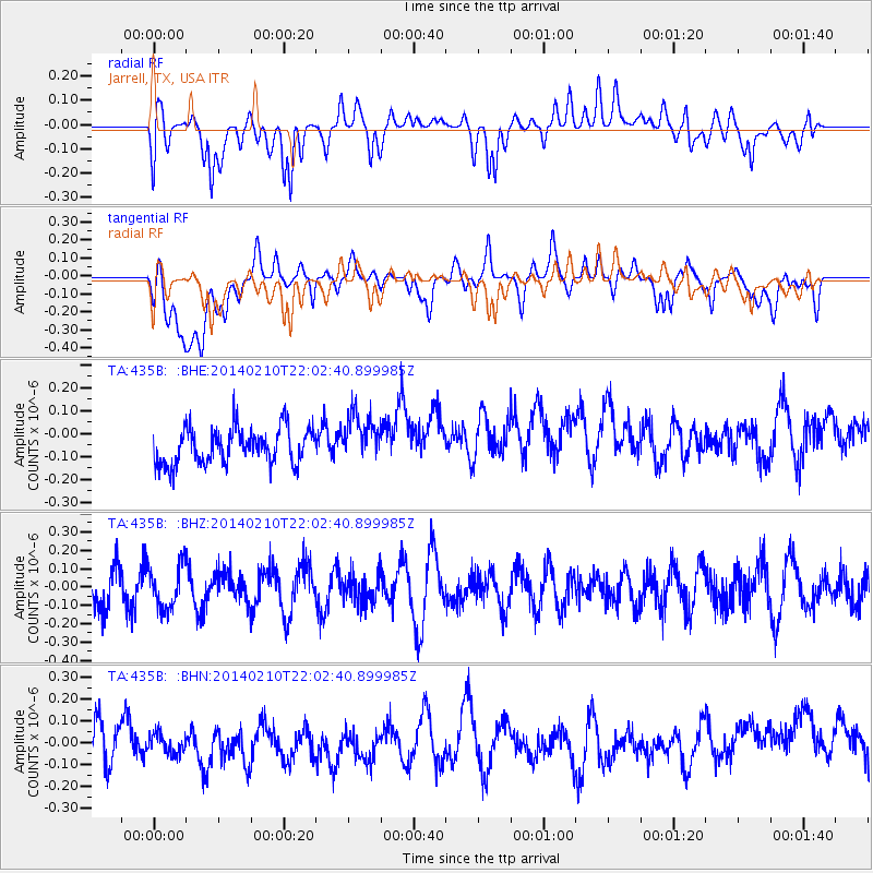
435B Jarrell, TX, USA - Earthquake Result Viewer
*The percent match for this event was below the threshold and hence no stack was calculated.
| Earthquake location: |
Kermadec Islands Region |
| Earthquake latitude/longitude: |
-29.2/-176.8 |
| Earthquake time(UTC): |
2014/02/10 (041) 21:49:48 GMT |
| Earthquake Depth: |
36 km |
| Earthquake Magnitude: |
5.0 MW |
| Earthquake Catalog/Contributor: |
ISC/ISC |
|
| Network: |
TA USArray Transportable Network (new EarthScope stations) |
| Station: |
435B Jarrell, TX, USA |
| Lat/Lon: |
30.78 N/97.58 W |
| Elevation: |
248 m |
|
| Distance: |
96.1 deg |
| Az: |
58.252 deg |
| Baz: |
239.753 deg |
| Ray Param: |
$rayparam |
*The percent match for this event was below the threshold and hence was not used in the summary stack. |
|
| Radial Match: |
51.45366 % |
| Radial Bump: |
400 |
| Transverse Match: |
36.44441 % |
| Transverse Bump: |
400 |
| SOD ConfigId: |
3390531 |
| Insert Time: |
2019-04-10 07:39:52.377 +0000 |
| GWidth: |
2.5 |
| Max Bumps: |
400 |
| Tol: |
0.001 |
|
Signal To Noise
| Channel | StoN | STA | LTA |
| TA:435B: :BHZ:20140210T22:02:40.899985Z | 1.1229091 | 1.18216306E-7 | 1.05276825E-7 |
| TA:435B: :BHN:20140210T22:02:40.899985Z | 0.722667 | 5.4857043E-8 | 7.5909156E-8 |
| TA:435B: :BHE:20140210T22:02:40.899985Z | 1.3741382 | 1.07923185E-7 | 7.853882E-8 |
| Arrivals |
| Ps | |
| PpPs | |
| PsPs/PpSs | |


