You are here: Home > Network List > TA - USArray Transportable Network (new EarthScope stations) Stations List
> Station R36A Gordon, Harris, KS, USA > Earthquake Result Viewer
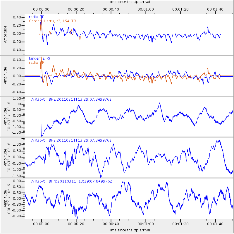
R36A Gordon, Harris, KS, USA - Earthquake Result Viewer
*The percent match for this event was below the threshold and hence no stack was calculated.
| Earthquake location: |
Near East Coast Of Honshu, Japan |
| Earthquake latitude/longitude: |
36.4/141.7 |
| Earthquake time(UTC): |
2011/03/11 (070) 13:16:51 GMT |
| Earthquake Depth: |
58 km |
| Earthquake Magnitude: |
5.6 MB |
| Earthquake Catalog/Contributor: |
WHDF/NEIC |
|
| Network: |
TA USArray Transportable Network (new EarthScope stations) |
| Station: |
R36A Gordon, Harris, KS, USA |
| Lat/Lon: |
38.32 N/95.50 W |
| Elevation: |
354 m |
|
| Distance: |
88.8 deg |
| Az: |
41.425 deg |
| Baz: |
317.24 deg |
| Ray Param: |
$rayparam |
*The percent match for this event was below the threshold and hence was not used in the summary stack. |
|
| Radial Match: |
61.53227 % |
| Radial Bump: |
400 |
| Transverse Match: |
45.577633 % |
| Transverse Bump: |
400 |
| SOD ConfigId: |
356183 |
| Insert Time: |
2011-08-16 09:23:10.478 +0000 |
| GWidth: |
2.5 |
| Max Bumps: |
400 |
| Tol: |
0.001 |
|
Signal To Noise
| Channel | StoN | STA | LTA |
| TA:R36A: :BHZ:20110311T13:29:07.849976Z | 1.2449876 | 5.1156724E-7 | 4.1090146E-7 |
| TA:R36A: :BHN:20110311T13:29:07.849976Z | 0.71995825 | 3.0943195E-7 | 4.2979153E-7 |
| TA:R36A: :BHE:20110311T13:29:07.849976Z | 0.80573887 | 5.553076E-7 | 6.891906E-7 |
| Arrivals |
| Ps | |
| PpPs | |
| PsPs/PpSs | |


