You are here: Home > Network List > TA - USArray Transportable Network (new EarthScope stations) Stations List
> Station R11A Troy Canyon, Currant, NV, USA > Earthquake Result Viewer
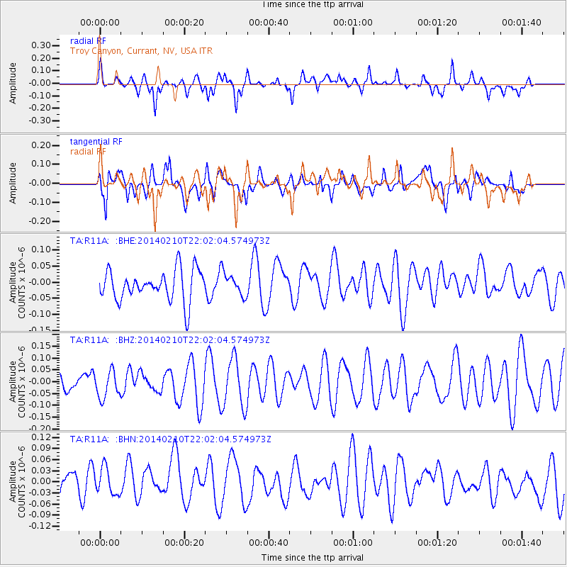
R11A Troy Canyon, Currant, NV, USA - Earthquake Result Viewer
*The percent match for this event was below the threshold and hence no stack was calculated.
| Earthquake location: |
Kermadec Islands Region |
| Earthquake latitude/longitude: |
-29.2/-176.8 |
| Earthquake time(UTC): |
2014/02/10 (041) 21:49:48 GMT |
| Earthquake Depth: |
36 km |
| Earthquake Magnitude: |
5.0 MW |
| Earthquake Catalog/Contributor: |
ISC/ISC |
|
| Network: |
TA USArray Transportable Network (new EarthScope stations) |
| Station: |
R11A Troy Canyon, Currant, NV, USA |
| Lat/Lon: |
38.35 N/115.59 W |
| Elevation: |
1756 m |
|
| Distance: |
88.2 deg |
| Az: |
43.602 deg |
| Baz: |
230.07 deg |
| Ray Param: |
$rayparam |
*The percent match for this event was below the threshold and hence was not used in the summary stack. |
|
| Radial Match: |
56.740974 % |
| Radial Bump: |
400 |
| Transverse Match: |
42.739475 % |
| Transverse Bump: |
400 |
| SOD ConfigId: |
3390531 |
| Insert Time: |
2019-04-10 07:39:59.791 +0000 |
| GWidth: |
2.5 |
| Max Bumps: |
400 |
| Tol: |
0.001 |
|
Signal To Noise
| Channel | StoN | STA | LTA |
| TA:R11A: :BHZ:20140210T22:02:04.574973Z | 0.7175972 | 5.8025044E-8 | 8.086019E-8 |
| TA:R11A: :BHN:20140210T22:02:04.574973Z | 0.93371147 | 4.4003944E-8 | 4.7127987E-8 |
| TA:R11A: :BHE:20140210T22:02:04.574973Z | 0.6882614 | 3.2883374E-8 | 4.777745E-8 |
| Arrivals |
| Ps | |
| PpPs | |
| PsPs/PpSs | |


