You are here: Home > Network List > TA - USArray Transportable Network (new EarthScope stations) Stations List
> Station K35A Storm Lake, IA, USA > Earthquake Result Viewer
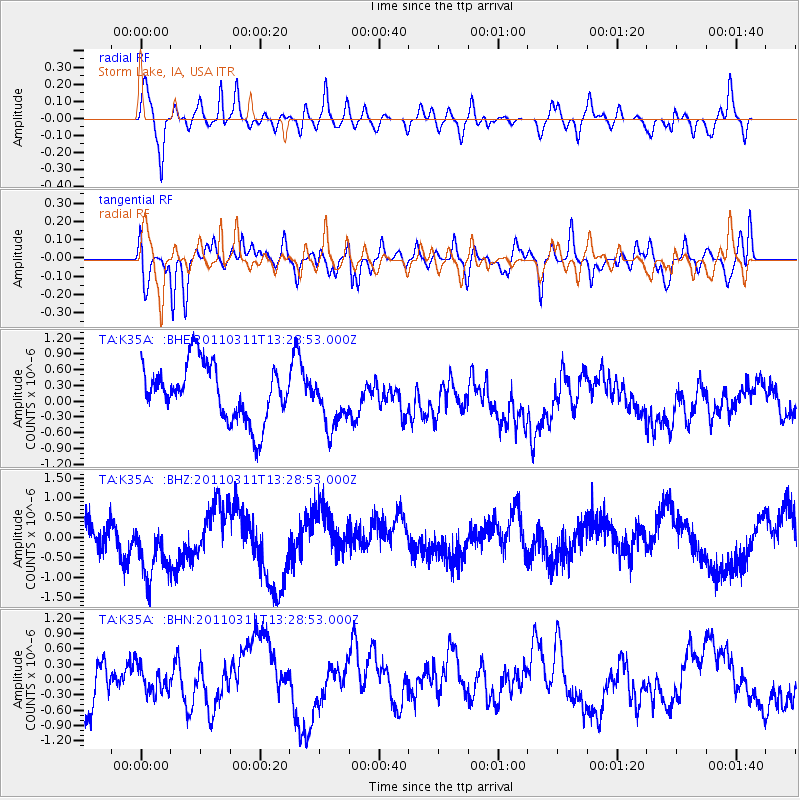
K35A Storm Lake, IA, USA - Earthquake Result Viewer
*The percent match for this event was below the threshold and hence no stack was calculated.
| Earthquake location: |
Near East Coast Of Honshu, Japan |
| Earthquake latitude/longitude: |
36.4/141.7 |
| Earthquake time(UTC): |
2011/03/11 (070) 13:16:51 GMT |
| Earthquake Depth: |
58 km |
| Earthquake Magnitude: |
5.6 MB |
| Earthquake Catalog/Contributor: |
WHDF/NEIC |
|
| Network: |
TA USArray Transportable Network (new EarthScope stations) |
| Station: |
K35A Storm Lake, IA, USA |
| Lat/Lon: |
42.72 N/95.23 W |
| Elevation: |
439 m |
|
| Distance: |
85.7 deg |
| Az: |
38.288 deg |
| Baz: |
317.265 deg |
| Ray Param: |
$rayparam |
*The percent match for this event was below the threshold and hence was not used in the summary stack. |
|
| Radial Match: |
52.296318 % |
| Radial Bump: |
400 |
| Transverse Match: |
53.417007 % |
| Transverse Bump: |
400 |
| SOD ConfigId: |
356183 |
| Insert Time: |
2011-08-16 09:34:03.028 +0000 |
| GWidth: |
2.5 |
| Max Bumps: |
400 |
| Tol: |
0.001 |
|
Signal To Noise
| Channel | StoN | STA | LTA |
| TA:K35A: :BHZ:20110311T13:28:53.000Z | 1.7547449 | 1.0622281E-6 | 6.053462E-7 |
| TA:K35A: :BHN:20110311T13:28:53.000Z | 0.38500485 | 2.5221274E-7 | 6.5508976E-7 |
| TA:K35A: :BHE:20110311T13:28:53.000Z | 0.960283 | 5.110607E-7 | 5.3219804E-7 |
| Arrivals |
| Ps | |
| PpPs | |
| PsPs/PpSs | |


