You are here: Home > Network List > US - United States National Seismic Network Stations List
> Station AMTX Amarillo, Texas, USA > Earthquake Result Viewer
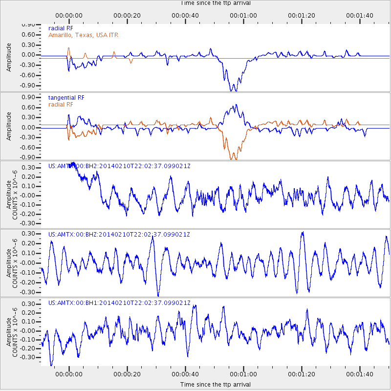
AMTX Amarillo, Texas, USA - Earthquake Result Viewer
*The percent match for this event was below the threshold and hence no stack was calculated.
| Earthquake location: |
Kermadec Islands Region |
| Earthquake latitude/longitude: |
-29.2/-176.8 |
| Earthquake time(UTC): |
2014/02/10 (041) 21:49:48 GMT |
| Earthquake Depth: |
36 km |
| Earthquake Magnitude: |
5.0 MW |
| Earthquake Catalog/Contributor: |
ISC/ISC |
|
| Network: |
US United States National Seismic Network |
| Station: |
AMTX Amarillo, Texas, USA |
| Lat/Lon: |
34.53 N/101.41 W |
| Elevation: |
1010 m |
|
| Distance: |
95.3 deg |
| Az: |
53.365 deg |
| Baz: |
238.185 deg |
| Ray Param: |
$rayparam |
*The percent match for this event was below the threshold and hence was not used in the summary stack. |
|
| Radial Match: |
25.678448 % |
| Radial Bump: |
400 |
| Transverse Match: |
37.43371 % |
| Transverse Bump: |
400 |
| SOD ConfigId: |
3390531 |
| Insert Time: |
2019-04-10 07:40:29.948 +0000 |
| GWidth: |
2.5 |
| Max Bumps: |
400 |
| Tol: |
0.001 |
|
Signal To Noise
| Channel | StoN | STA | LTA |
| US:AMTX:00:BHZ:20140210T22:02:37.099021Z | 0.49194437 | 5.3937043E-8 | 1.0964053E-7 |
| US:AMTX:00:BH1:20140210T22:02:37.099021Z | 0.926217 | 2.7934487E-7 | 3.0159768E-7 |
| US:AMTX:00:BH2:20140210T22:02:37.099021Z | 0.9487701 | 1.425847E-7 | 1.5028373E-7 |
| Arrivals |
| Ps | |
| PpPs | |
| PsPs/PpSs | |


