You are here: Home > Network List > TA - USArray Transportable Network (new EarthScope stations) Stations List
> Station K37A Belmond, IA, USA > Earthquake Result Viewer
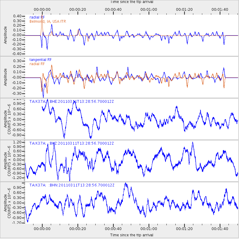
K37A Belmond, IA, USA - Earthquake Result Viewer
*The percent match for this event was below the threshold and hence no stack was calculated.
| Earthquake location: |
Near East Coast Of Honshu, Japan |
| Earthquake latitude/longitude: |
36.4/141.7 |
| Earthquake time(UTC): |
2011/03/11 (070) 13:16:51 GMT |
| Earthquake Depth: |
58 km |
| Earthquake Magnitude: |
5.6 MB |
| Earthquake Catalog/Contributor: |
WHDF/NEIC |
|
| Network: |
TA USArray Transportable Network (new EarthScope stations) |
| Station: |
K37A Belmond, IA, USA |
| Lat/Lon: |
42.77 N/93.64 W |
| Elevation: |
365 m |
|
| Distance: |
86.5 deg |
| Az: |
37.386 deg |
| Baz: |
318.281 deg |
| Ray Param: |
$rayparam |
*The percent match for this event was below the threshold and hence was not used in the summary stack. |
|
| Radial Match: |
53.268524 % |
| Radial Bump: |
400 |
| Transverse Match: |
31.725296 % |
| Transverse Bump: |
317 |
| SOD ConfigId: |
356183 |
| Insert Time: |
2011-08-16 09:42:57.518 +0000 |
| GWidth: |
2.5 |
| Max Bumps: |
400 |
| Tol: |
0.001 |
|
Signal To Noise
| Channel | StoN | STA | LTA |
| TA:K37A: :BHZ:20110311T13:28:56.700012Z | 0.92718613 | 5.730773E-7 | 6.180822E-7 |
| TA:K37A: :BHN:20110311T13:28:56.700012Z | 0.39299303 | 2.3888975E-7 | 6.078728E-7 |
| TA:K37A: :BHE:20110311T13:28:56.700012Z | 0.95139533 | 4.6990348E-7 | 4.939098E-7 |
| Arrivals |
| Ps | |
| PpPs | |
| PsPs/PpSs | |


