You are here: Home > Network List > TA - USArray Transportable Network (new EarthScope stations) Stations List
> Station T38A Diamond, MO, USA > Earthquake Result Viewer
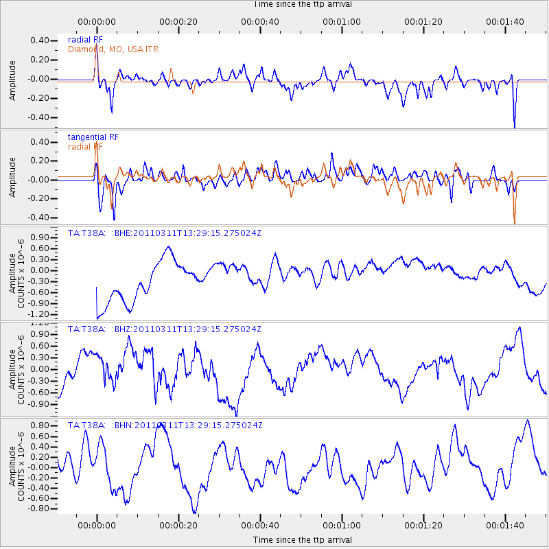
T38A Diamond, MO, USA - Earthquake Result Viewer
*The percent match for this event was below the threshold and hence no stack was calculated.
| Earthquake location: |
Near East Coast Of Honshu, Japan |
| Earthquake latitude/longitude: |
36.4/141.7 |
| Earthquake time(UTC): |
2011/03/11 (070) 13:16:51 GMT |
| Earthquake Depth: |
58 km |
| Earthquake Magnitude: |
5.6 MB |
| Earthquake Catalog/Contributor: |
WHDF/NEIC |
|
| Network: |
TA USArray Transportable Network (new EarthScope stations) |
| Station: |
T38A Diamond, MO, USA |
| Lat/Lon: |
37.04 N/94.29 W |
| Elevation: |
349 m |
|
| Distance: |
90.4 deg |
| Az: |
41.582 deg |
| Baz: |
317.979 deg |
| Ray Param: |
$rayparam |
*The percent match for this event was below the threshold and hence was not used in the summary stack. |
|
| Radial Match: |
58.938953 % |
| Radial Bump: |
400 |
| Transverse Match: |
55.174828 % |
| Transverse Bump: |
400 |
| SOD ConfigId: |
356183 |
| Insert Time: |
2011-08-16 09:48:56.660 +0000 |
| GWidth: |
2.5 |
| Max Bumps: |
400 |
| Tol: |
0.001 |
|
Signal To Noise
| Channel | StoN | STA | LTA |
| TA:T38A: :BHZ:20110311T13:29:15.275024Z | 0.87436473 | 3.6810206E-7 | 4.2099373E-7 |
| TA:T38A: :BHN:20110311T13:29:15.275024Z | 0.895696 | 4.3975766E-7 | 4.909675E-7 |
| TA:T38A: :BHE:20110311T13:29:15.275024Z | 0.88143456 | 4.8110394E-7 | 5.458192E-7 |
| Arrivals |
| Ps | |
| PpPs | |
| PsPs/PpSs | |


