You are here: Home > Network List > TA - USArray Transportable Network (new EarthScope stations) Stations List
> Station V39A Pettigrew, AR, USA > Earthquake Result Viewer
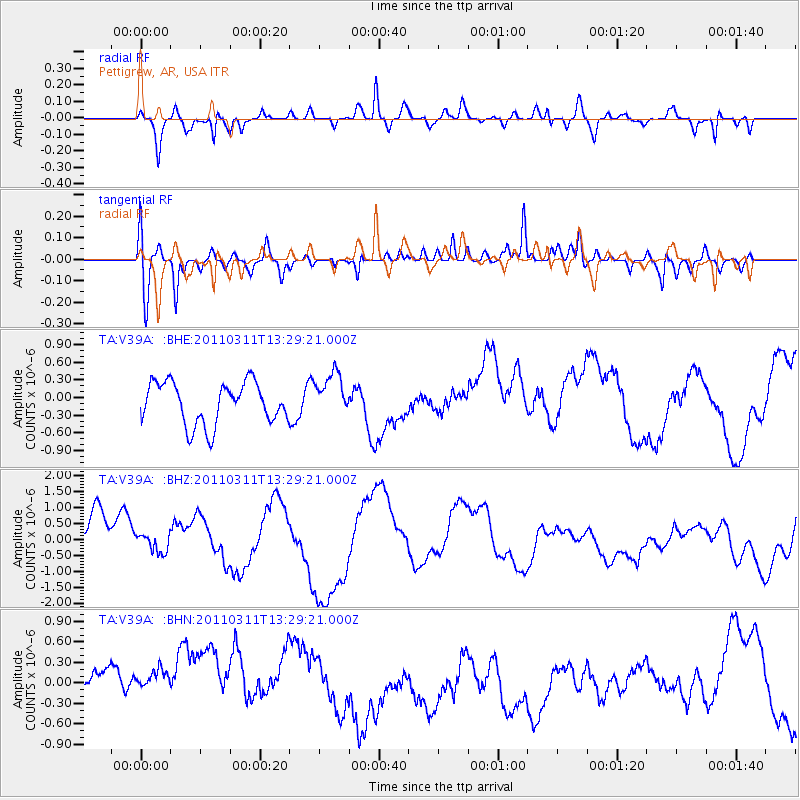
V39A Pettigrew, AR, USA - Earthquake Result Viewer
*The percent match for this event was below the threshold and hence no stack was calculated.
| Earthquake location: |
Near East Coast Of Honshu, Japan |
| Earthquake latitude/longitude: |
36.4/141.7 |
| Earthquake time(UTC): |
2011/03/11 (070) 13:16:51 GMT |
| Earthquake Depth: |
58 km |
| Earthquake Magnitude: |
5.6 MB |
| Earthquake Catalog/Contributor: |
WHDF/NEIC |
|
| Network: |
TA USArray Transportable Network (new EarthScope stations) |
| Station: |
V39A Pettigrew, AR, USA |
| Lat/Lon: |
35.84 N/93.64 W |
| Elevation: |
744 m |
|
| Distance: |
91.6 deg |
| Az: |
41.989 deg |
| Baz: |
318.355 deg |
| Ray Param: |
$rayparam |
*The percent match for this event was below the threshold and hence was not used in the summary stack. |
|
| Radial Match: |
67.58276 % |
| Radial Bump: |
373 |
| Transverse Match: |
63.456406 % |
| Transverse Bump: |
400 |
| SOD ConfigId: |
356183 |
| Insert Time: |
2011-08-16 09:49:40.795 +0000 |
| GWidth: |
2.5 |
| Max Bumps: |
400 |
| Tol: |
0.001 |
|
Signal To Noise
| Channel | StoN | STA | LTA |
| TA:V39A: :BHZ:20110311T13:29:21.000Z | 0.45291921 | 2.8166374E-7 | 6.2188514E-7 |
| TA:V39A: :BHN:20110311T13:29:21.000Z | 1.2637142 | 5.505912E-7 | 4.3569287E-7 |
| TA:V39A: :BHE:20110311T13:29:21.000Z | 1.0658481 | 3.78589E-7 | 3.5519977E-7 |
| Arrivals |
| Ps | |
| PpPs | |
| PsPs/PpSs | |


