You are here: Home > Network List > CN - Canadian National Seismograph Network Stations List
> Station INK INUVIK, NT, CANADA.ANADA > Earthquake Result Viewer
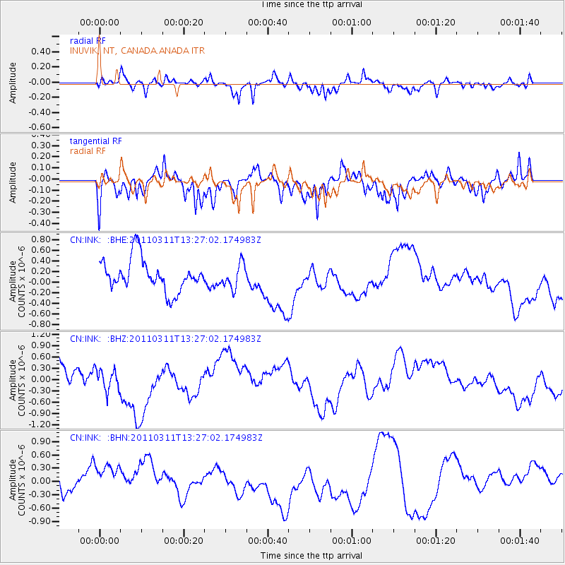
INK INUVIK, NT, CANADA.ANADA - Earthquake Result Viewer
*The percent match for this event was below the threshold and hence no stack was calculated.
| Earthquake location: |
Off East Coast Of Honshu, Japan |
| Earthquake latitude/longitude: |
37.6/142.8 |
| Earthquake time(UTC): |
2011/03/11 (070) 13:18:16 GMT |
| Earthquake Depth: |
35 km |
| Earthquake Magnitude: |
5.5 MB |
| Earthquake Catalog/Contributor: |
WHDF/NEIC |
|
| Network: |
CN Canadian National Seismograph Network |
| Station: |
INK INUVIK, NT, CANADA.ANADA |
| Lat/Lon: |
68.31 N/133.52 W |
| Elevation: |
40 m |
|
| Distance: |
53.4 deg |
| Az: |
27.408 deg |
| Baz: |
280.35 deg |
| Ray Param: |
$rayparam |
*The percent match for this event was below the threshold and hence was not used in the summary stack. |
|
| Radial Match: |
54.95424 % |
| Radial Bump: |
379 |
| Transverse Match: |
55.46313 % |
| Transverse Bump: |
388 |
| SOD ConfigId: |
356183 |
| Insert Time: |
2011-08-16 10:42:27.663 +0000 |
| GWidth: |
2.5 |
| Max Bumps: |
400 |
| Tol: |
0.001 |
|
Signal To Noise
| Channel | StoN | STA | LTA |
| CN:INK: :BHZ:20110311T13:27:02.174983Z | 0.734921 | 2.753834E-7 | 3.747116E-7 |
| CN:INK: :BHN:20110311T13:27:02.174983Z | 1.0674958 | 5.9082413E-7 | 5.534674E-7 |
| CN:INK: :BHE:20110311T13:27:02.174983Z | 0.7774769 | 2.3272094E-7 | 2.993284E-7 |
| Arrivals |
| Ps | |
| PpPs | |
| PsPs/PpSs | |


