You are here: Home > Network List > TA - USArray Transportable Network (new EarthScope stations) Stations List
> Station 535A Dale, TX, USA > Earthquake Result Viewer
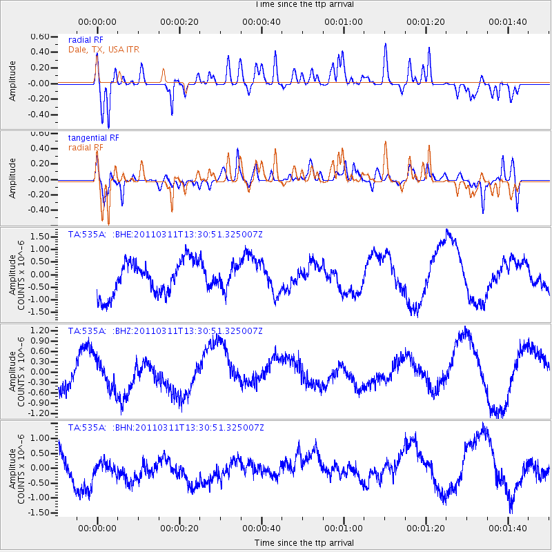
535A Dale, TX, USA - Earthquake Result Viewer
*The percent match for this event was below the threshold and hence no stack was calculated.
| Earthquake location: |
Off East Coast Of Honshu, Japan |
| Earthquake latitude/longitude: |
37.6/142.8 |
| Earthquake time(UTC): |
2011/03/11 (070) 13:18:16 GMT |
| Earthquake Depth: |
35 km |
| Earthquake Magnitude: |
5.5 MB |
| Earthquake Catalog/Contributor: |
WHDF/NEIC |
|
| Network: |
TA USArray Transportable Network (new EarthScope stations) |
| Station: |
535A Dale, TX, USA |
| Lat/Lon: |
30.03 N/97.57 W |
| Elevation: |
170 m |
|
| Distance: |
92.2 deg |
| Az: |
48.988 deg |
| Baz: |
316.265 deg |
| Ray Param: |
$rayparam |
*The percent match for this event was below the threshold and hence was not used in the summary stack. |
|
| Radial Match: |
72.25261 % |
| Radial Bump: |
400 |
| Transverse Match: |
49.961937 % |
| Transverse Bump: |
400 |
| SOD ConfigId: |
356183 |
| Insert Time: |
2011-08-16 12:02:36.632 +0000 |
| GWidth: |
2.5 |
| Max Bumps: |
400 |
| Tol: |
0.001 |
|
Signal To Noise
| Channel | StoN | STA | LTA |
| TA:535A: :BHZ:20110311T13:30:51.325007Z | 0.89812464 | 4.2586214E-7 | 4.7416822E-7 |
| TA:535A: :BHN:20110311T13:30:51.325007Z | 0.6254815 | 5.3366364E-7 | 8.5320454E-7 |
| TA:535A: :BHE:20110311T13:30:51.325007Z | 0.6477264 | 4.3264095E-7 | 6.6793774E-7 |
| Arrivals |
| Ps | |
| PpPs | |
| PsPs/PpSs | |


