You are here: Home > Network List > TA - USArray Transportable Network (new EarthScope stations) Stations List
> Station Z38A Mt. Pleasant, TX, USA > Earthquake Result Viewer
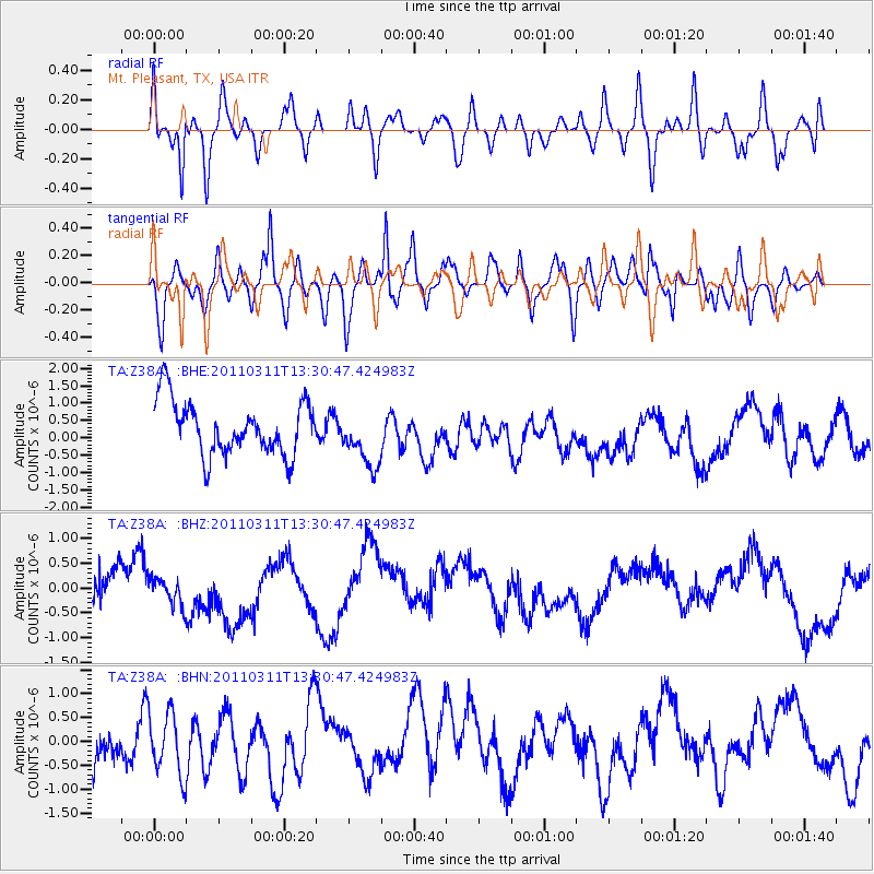
Z38A Mt. Pleasant, TX, USA - Earthquake Result Viewer
*The percent match for this event was below the threshold and hence no stack was calculated.
| Earthquake location: |
Off East Coast Of Honshu, Japan |
| Earthquake latitude/longitude: |
37.6/142.8 |
| Earthquake time(UTC): |
2011/03/11 (070) 13:18:16 GMT |
| Earthquake Depth: |
35 km |
| Earthquake Magnitude: |
5.5 MB |
| Earthquake Catalog/Contributor: |
WHDF/NEIC |
|
| Network: |
TA USArray Transportable Network (new EarthScope stations) |
| Station: |
Z38A Mt. Pleasant, TX, USA |
| Lat/Lon: |
33.25 N/94.99 W |
| Elevation: |
116 m |
|
| Distance: |
91.3 deg |
| Az: |
45.184 deg |
| Baz: |
317.732 deg |
| Ray Param: |
$rayparam |
*The percent match for this event was below the threshold and hence was not used in the summary stack. |
|
| Radial Match: |
55.01611 % |
| Radial Bump: |
400 |
| Transverse Match: |
52.724205 % |
| Transverse Bump: |
400 |
| SOD ConfigId: |
356183 |
| Insert Time: |
2011-08-16 12:06:16.145 +0000 |
| GWidth: |
2.5 |
| Max Bumps: |
400 |
| Tol: |
0.001 |
|
Signal To Noise
| Channel | StoN | STA | LTA |
| TA:Z38A: :BHZ:20110311T13:30:47.424983Z | 0.9828708 | 3.0530325E-7 | 3.1062396E-7 |
| TA:Z38A: :BHN:20110311T13:30:47.424983Z | 0.935536 | 6.7146055E-7 | 7.1772814E-7 |
| TA:Z38A: :BHE:20110311T13:30:47.424983Z | 1.0782903 | 8.3006967E-7 | 7.6980166E-7 |
| Arrivals |
| Ps | |
| PpPs | |
| PsPs/PpSs | |


