You are here: Home > Network List > TA - USArray Transportable Network (new EarthScope stations) Stations List
> Station ABTX Abilene, Hawley, TX, USA > Earthquake Result Viewer
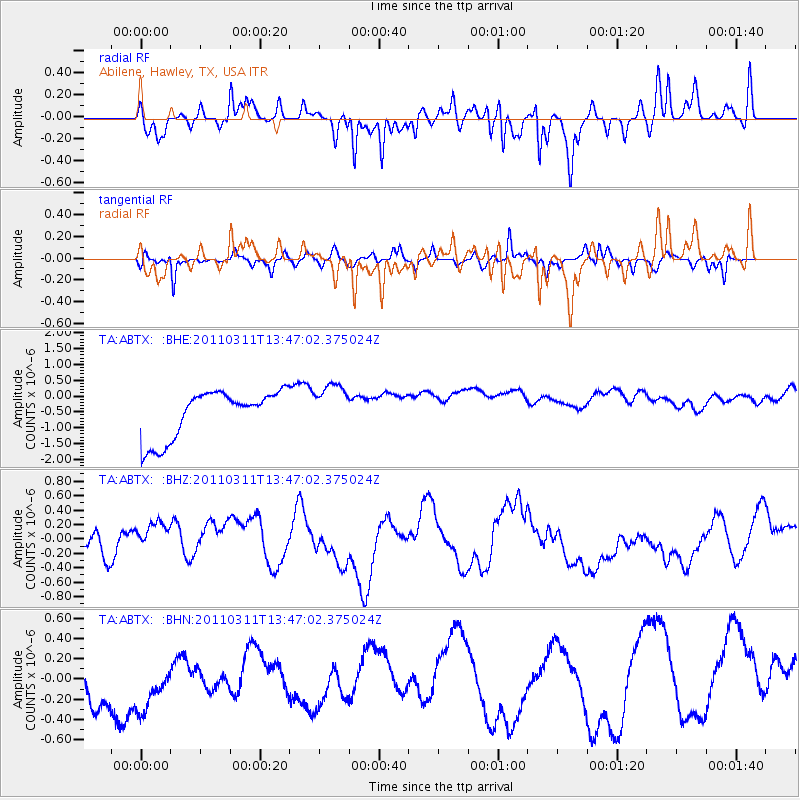
ABTX Abilene, Hawley, TX, USA - Earthquake Result Viewer
*The percent match for this event was below the threshold and hence no stack was calculated.
| Earthquake location: |
Near East Coast Of Honshu, Japan |
| Earthquake latitude/longitude: |
36.2/141.8 |
| Earthquake time(UTC): |
2011/03/11 (070) 13:34:30 GMT |
| Earthquake Depth: |
4.7 km |
| Earthquake Magnitude: |
5.5 MB |
| Earthquake Catalog/Contributor: |
WHDF/NEIC |
|
| Network: |
TA USArray Transportable Network (new EarthScope stations) |
| Station: |
ABTX Abilene, Hawley, TX, USA |
| Lat/Lon: |
32.62 N/99.64 W |
| Elevation: |
502 m |
|
| Distance: |
90.6 deg |
| Az: |
47.862 deg |
| Baz: |
314.676 deg |
| Ray Param: |
$rayparam |
*The percent match for this event was below the threshold and hence was not used in the summary stack. |
|
| Radial Match: |
48.771847 % |
| Radial Bump: |
366 |
| Transverse Match: |
57.474957 % |
| Transverse Bump: |
323 |
| SOD ConfigId: |
356183 |
| Insert Time: |
2011-08-16 13:57:36.277 +0000 |
| GWidth: |
2.5 |
| Max Bumps: |
400 |
| Tol: |
0.001 |
|
Signal To Noise
| Channel | StoN | STA | LTA |
| TA:ABTX: :BHZ:20110311T13:47:02.375024Z | 1.0844754 | 3.0475584E-7 | 2.8101684E-7 |
| TA:ABTX: :BHN:20110311T13:47:02.375024Z | 0.88936645 | 5.041642E-7 | 5.6688015E-7 |
| TA:ABTX: :BHE:20110311T13:47:02.375024Z | 0.9722567 | 7.321799E-7 | 7.5307264E-7 |
| Arrivals |
| Ps | |
| PpPs | |
| PsPs/PpSs | |


