You are here: Home > Network List > TA - USArray Transportable Network (new EarthScope stations) Stations List
> Station N34A Lincoln, NE, USA > Earthquake Result Viewer
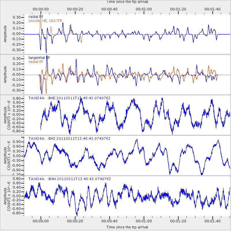
N34A Lincoln, NE, USA - Earthquake Result Viewer
*The percent match for this event was below the threshold and hence no stack was calculated.
| Earthquake location: |
Near East Coast Of Honshu, Japan |
| Earthquake latitude/longitude: |
36.2/141.8 |
| Earthquake time(UTC): |
2011/03/11 (070) 13:34:30 GMT |
| Earthquake Depth: |
4.7 km |
| Earthquake Magnitude: |
5.5 MB |
| Earthquake Catalog/Contributor: |
WHDF/NEIC |
|
| Network: |
TA USArray Transportable Network (new EarthScope stations) |
| Station: |
N34A Lincoln, NE, USA |
| Lat/Lon: |
40.84 N/96.50 W |
| Elevation: |
401 m |
|
| Distance: |
86.5 deg |
| Az: |
40.316 deg |
| Baz: |
316.365 deg |
| Ray Param: |
$rayparam |
*The percent match for this event was below the threshold and hence was not used in the summary stack. |
|
| Radial Match: |
47.359512 % |
| Radial Bump: |
355 |
| Transverse Match: |
64.493576 % |
| Transverse Bump: |
357 |
| SOD ConfigId: |
356183 |
| Insert Time: |
2011-08-16 14:32:44.995 +0000 |
| GWidth: |
2.5 |
| Max Bumps: |
400 |
| Tol: |
0.001 |
|
Signal To Noise
| Channel | StoN | STA | LTA |
| TA:N34A: :BHZ:20110311T13:46:43.074976Z | 0.76189274 | 3.7674548E-7 | 4.9448624E-7 |
| TA:N34A: :BHN:20110311T13:46:43.074976Z | 1.1756163 | 4.4375446E-7 | 3.774654E-7 |
| TA:N34A: :BHE:20110311T13:46:43.074976Z | 1.1208509 | 4.4352527E-7 | 3.957041E-7 |
| Arrivals |
| Ps | |
| PpPs | |
| PsPs/PpSs | |


