You are here: Home > Network List > US - United States National Seismic Network Stations List
> Station EGMT Eagleton, Montana, USA > Earthquake Result Viewer
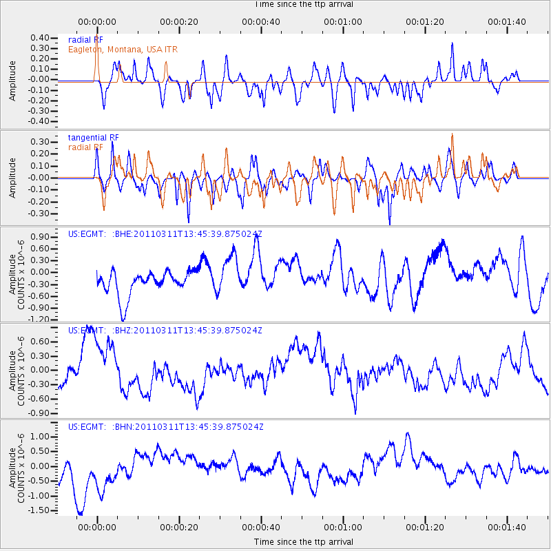
EGMT Eagleton, Montana, USA - Earthquake Result Viewer
*The percent match for this event was below the threshold and hence no stack was calculated.
| Earthquake location: |
Near East Coast Of Honshu, Japan |
| Earthquake latitude/longitude: |
36.2/141.8 |
| Earthquake time(UTC): |
2011/03/11 (070) 13:34:30 GMT |
| Earthquake Depth: |
4.7 km |
| Earthquake Magnitude: |
5.5 MB |
| Earthquake Catalog/Contributor: |
WHDF/NEIC |
|
| Network: |
US United States National Seismic Network |
| Station: |
EGMT Eagleton, Montana, USA |
| Lat/Lon: |
48.02 N/109.75 W |
| Elevation: |
1055 m |
|
| Distance: |
74.7 deg |
| Az: |
41.328 deg |
| Baz: |
307.244 deg |
| Ray Param: |
$rayparam |
*The percent match for this event was below the threshold and hence was not used in the summary stack. |
|
| Radial Match: |
54.16158 % |
| Radial Bump: |
400 |
| Transverse Match: |
58.44533 % |
| Transverse Bump: |
400 |
| SOD ConfigId: |
356183 |
| Insert Time: |
2011-08-16 15:19:35.313 +0000 |
| GWidth: |
2.5 |
| Max Bumps: |
400 |
| Tol: |
0.001 |
|
Signal To Noise
| Channel | StoN | STA | LTA |
| US:EGMT: :BHZ:20110311T13:45:39.875024Z | 1.5211014 | 5.681066E-7 | 3.7348374E-7 |
| US:EGMT: :BHN:20110311T13:45:39.875024Z | 1.7225598 | 8.9982916E-7 | 5.22379E-7 |
| US:EGMT: :BHE:20110311T13:45:39.875024Z | 1.7018819 | 5.1936746E-7 | 3.0517245E-7 |
| Arrivals |
| Ps | |
| PpPs | |
| PsPs/PpSs | |


