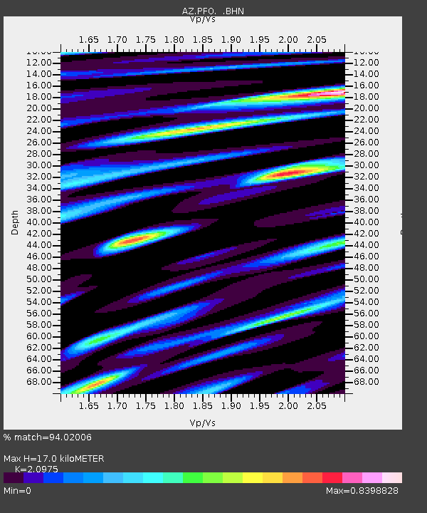
PFO AZ.PFO - Earthquake Result Viewer

Earthquake location: Panama-Costa Rica Border Region
Earthquake latitude/longitude: 8.4/-82.8
Earthquake time(UTC): 2003/12/25 (359) 07:11:11 GMT
Earthquake Depth: 33 km
Earthquake Magnitude: 6.0 MB, 6.4 MS, 6.5 MW, 6.5 MW
Earthquake Catalog/Contributor: WHDF/NEIC
Network: AZ ANZA Regional Network
Station: PFO AZ.PFO
Lat/Lon: 33.61 N/116.46 W
Elevation: 1259 m
Distance: 39.9 deg
Az: 313.853 deg
Baz: 121.248 deg
Ray Param: 0.07466494
Estimated Moho Depth: 17.0 km
Estimated Crust Vp/Vs: 2.10
Assumed Crust Vp: 6.264 km/s
Estimated Crust Vs: 2.986 km/s
Estimated Crust Poisson's Ratio: 0.35
Radial Match: 94.02006 %
Radial Bump: 400
Transverse Match: 78.01839 %
Transverse Bump: 400
SOD ConfigId: 32974
Insert Time: 2010-02-26 20:07:36.938 +0000
GWidth: 2.5
Max Bumps: 400
Tol: 0.001

Signal To Noise

ChannelStoNSTALTA
AZ:PFO: :BHN:20031225T07:18:11.64899Z1.6682013.203007E-71.9200367E-7
AZ:PFO: :BHE:20031225T07:18:11.64899Z2.25713374.5874867E-72.0324391E-7
AZ:PFO: :BHZ:20031225T07:18:11.64899Z3.21055276.011877E-71.8725365E-7
Arrivals
Ps3.2 SECOND
PpPs7.9 SECOND
PsPs/PpSs11 SECOND