You are here: Home > Network List > TA - USArray Transportable Network (new EarthScope stations) Stations List
> Station MSTX Muleshoe, TX, USA > Earthquake Result Viewer
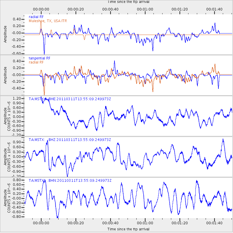
MSTX Muleshoe, TX, USA - Earthquake Result Viewer
*The percent match for this event was below the threshold and hence no stack was calculated.
| Earthquake location: |
Off East Coast Of Honshu, Japan |
| Earthquake latitude/longitude: |
39.0/144.1 |
| Earthquake time(UTC): |
2011/03/11 (070) 13:43:09 GMT |
| Earthquake Depth: |
25 km |
| Earthquake Magnitude: |
5.7 MB |
| Earthquake Catalog/Contributor: |
WHDF/NEIC |
|
| Network: |
TA USArray Transportable Network (new EarthScope stations) |
| Station: |
MSTX Muleshoe, TX, USA |
| Lat/Lon: |
33.97 N/102.77 W |
| Elevation: |
1167 m |
|
| Distance: |
84.6 deg |
| Az: |
50.161 deg |
| Baz: |
313.942 deg |
| Ray Param: |
$rayparam |
*The percent match for this event was below the threshold and hence was not used in the summary stack. |
|
| Radial Match: |
62.2945 % |
| Radial Bump: |
334 |
| Transverse Match: |
50.149002 % |
| Transverse Bump: |
266 |
| SOD ConfigId: |
356183 |
| Insert Time: |
2011-08-16 16:34:50.651 +0000 |
| GWidth: |
2.5 |
| Max Bumps: |
400 |
| Tol: |
0.001 |
|
Signal To Noise
| Channel | StoN | STA | LTA |
| TA:MSTX: :BHZ:20110311T13:55:09.249973Z | 1.4783543 | 5.3216667E-7 | 3.5997235E-7 |
| TA:MSTX: :BHN:20110311T13:55:09.249973Z | 1.4253434 | 7.98797E-7 | 5.604242E-7 |
| TA:MSTX: :BHE:20110311T13:55:09.249973Z | 1.0373621 | 5.966976E-7 | 5.752067E-7 |
| Arrivals |
| Ps | |
| PpPs | |
| PsPs/PpSs | |


