You are here: Home > Network List > TA - USArray Transportable Network (new EarthScope stations) Stations List
> Station 121A Cookes Peak, Deming, NM, USA > Earthquake Result Viewer
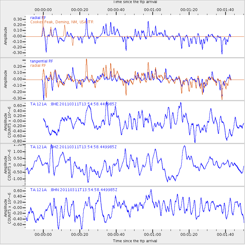
121A Cookes Peak, Deming, NM, USA - Earthquake Result Viewer
*The percent match for this event was below the threshold and hence no stack was calculated.
| Earthquake location: |
Off East Coast Of Honshu, Japan |
| Earthquake latitude/longitude: |
39.0/144.1 |
| Earthquake time(UTC): |
2011/03/11 (070) 13:43:09 GMT |
| Earthquake Depth: |
25 km |
| Earthquake Magnitude: |
5.7 MB |
| Earthquake Catalog/Contributor: |
WHDF/NEIC |
|
| Network: |
TA USArray Transportable Network (new EarthScope stations) |
| Station: |
121A Cookes Peak, Deming, NM, USA |
| Lat/Lon: |
32.53 N/107.79 W |
| Elevation: |
1652 m |
|
| Distance: |
82.5 deg |
| Az: |
54.091 deg |
| Baz: |
311.648 deg |
| Ray Param: |
$rayparam |
*The percent match for this event was below the threshold and hence was not used in the summary stack. |
|
| Radial Match: |
64.26885 % |
| Radial Bump: |
348 |
| Transverse Match: |
66.62086 % |
| Transverse Bump: |
339 |
| SOD ConfigId: |
356183 |
| Insert Time: |
2011-08-16 16:34:52.132 +0000 |
| GWidth: |
2.5 |
| Max Bumps: |
400 |
| Tol: |
0.001 |
|
Signal To Noise
| Channel | StoN | STA | LTA |
| TA:121A: :BHZ:20110311T13:54:58.449985Z | 2.0493176 | 6.590413E-7 | 3.215906E-7 |
| TA:121A: :BHN:20110311T13:54:58.449985Z | 0.6792378 | 5.309988E-7 | 7.817569E-7 |
| TA:121A: :BHE:20110311T13:54:58.449985Z | 1.0996348 | 2.8343902E-7 | 2.5775745E-7 |
| Arrivals |
| Ps | |
| PpPs | |
| PsPs/PpSs | |


