You are here: Home > Network List > TA - USArray Transportable Network (new EarthScope stations) Stations List
> Station H28A Mission Ridge, SD, USA > Earthquake Result Viewer
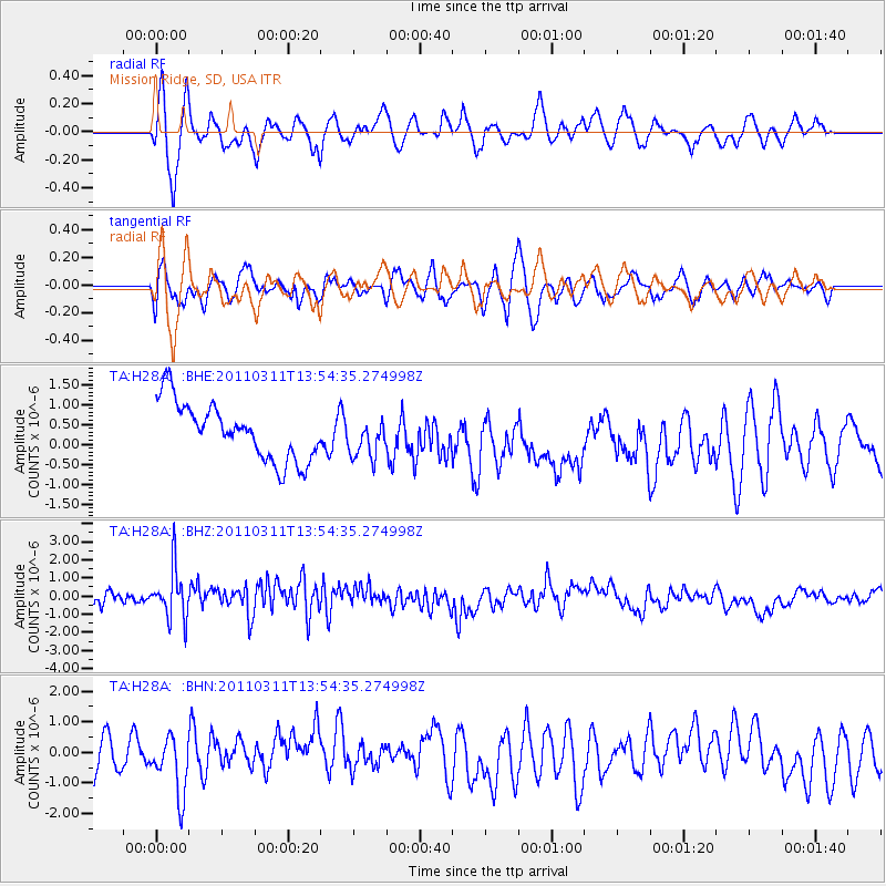
H28A Mission Ridge, SD, USA - Earthquake Result Viewer
*The percent match for this event was below the threshold and hence no stack was calculated.
| Earthquake location: |
Off East Coast Of Honshu, Japan |
| Earthquake latitude/longitude: |
39.0/144.1 |
| Earthquake time(UTC): |
2011/03/11 (070) 13:43:09 GMT |
| Earthquake Depth: |
25 km |
| Earthquake Magnitude: |
5.7 MB |
| Earthquake Catalog/Contributor: |
WHDF/NEIC |
|
| Network: |
TA USArray Transportable Network (new EarthScope stations) |
| Station: |
H28A Mission Ridge, SD, USA |
| Lat/Lon: |
44.68 N/101.02 W |
| Elevation: |
642 m |
|
| Distance: |
78.1 deg |
| Az: |
41.413 deg |
| Baz: |
313.734 deg |
| Ray Param: |
$rayparam |
*The percent match for this event was below the threshold and hence was not used in the summary stack. |
|
| Radial Match: |
62.082825 % |
| Radial Bump: |
400 |
| Transverse Match: |
51.98811 % |
| Transverse Bump: |
400 |
| SOD ConfigId: |
356183 |
| Insert Time: |
2011-08-16 16:45:27.598 +0000 |
| GWidth: |
2.5 |
| Max Bumps: |
400 |
| Tol: |
0.001 |
|
Signal To Noise
| Channel | StoN | STA | LTA |
| TA:H28A: :BHZ:20110311T13:54:35.274998Z | 4.6239333 | 1.4043311E-6 | 3.0370921E-7 |
| TA:H28A: :BHN:20110311T13:54:35.274998Z | 2.0425367 | 9.455228E-7 | 4.6291592E-7 |
| TA:H28A: :BHE:20110311T13:54:35.274998Z | 0.6648379 | 4.7613935E-7 | 7.161736E-7 |
| Arrivals |
| Ps | |
| PpPs | |
| PsPs/PpSs | |


