You are here: Home > Network List > TA - USArray Transportable Network (new EarthScope stations) Stations List
> Station H25A Fruitdale, SD, USA > Earthquake Result Viewer
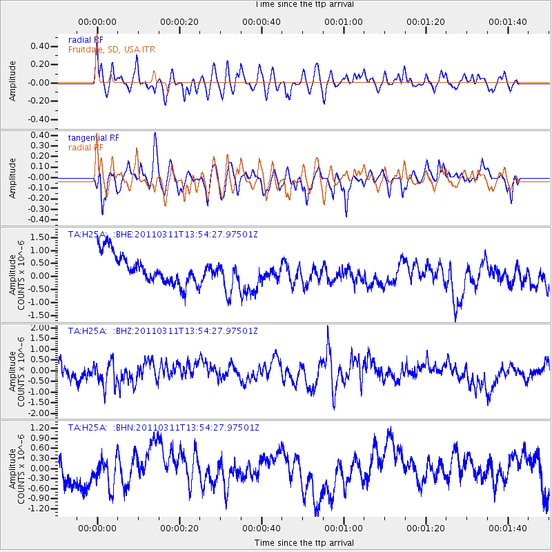
H25A Fruitdale, SD, USA - Earthquake Result Viewer
*The percent match for this event was below the threshold and hence no stack was calculated.
| Earthquake location: |
Off East Coast Of Honshu, Japan |
| Earthquake latitude/longitude: |
39.0/144.1 |
| Earthquake time(UTC): |
2011/03/11 (070) 13:43:09 GMT |
| Earthquake Depth: |
25 km |
| Earthquake Magnitude: |
5.7 MB |
| Earthquake Catalog/Contributor: |
WHDF/NEIC |
|
| Network: |
TA USArray Transportable Network (new EarthScope stations) |
| Station: |
H25A Fruitdale, SD, USA |
| Lat/Lon: |
44.62 N/103.60 W |
| Elevation: |
942 m |
|
| Distance: |
76.8 deg |
| Az: |
42.738 deg |
| Baz: |
312.216 deg |
| Ray Param: |
$rayparam |
*The percent match for this event was below the threshold and hence was not used in the summary stack. |
|
| Radial Match: |
51.124523 % |
| Radial Bump: |
400 |
| Transverse Match: |
59.017555 % |
| Transverse Bump: |
400 |
| SOD ConfigId: |
356183 |
| Insert Time: |
2011-08-16 16:46:18.690 +0000 |
| GWidth: |
2.5 |
| Max Bumps: |
400 |
| Tol: |
0.001 |
|
Signal To Noise
| Channel | StoN | STA | LTA |
| TA:H25A: :BHZ:20110311T13:54:27.97501Z | 1.6752938 | 5.745792E-7 | 3.429722E-7 |
| TA:H25A: :BHN:20110311T13:54:27.97501Z | 1.144906 | 4.4296266E-7 | 3.868987E-7 |
| TA:H25A: :BHE:20110311T13:54:27.97501Z | 1.1614475 | 6.5557055E-7 | 5.6444264E-7 |
| Arrivals |
| Ps | |
| PpPs | |
| PsPs/PpSs | |


