You are here: Home > Network List > TA - USArray Transportable Network (new EarthScope stations) Stations List
> Station Z38A Mt. Pleasant, TX, USA > Earthquake Result Viewer
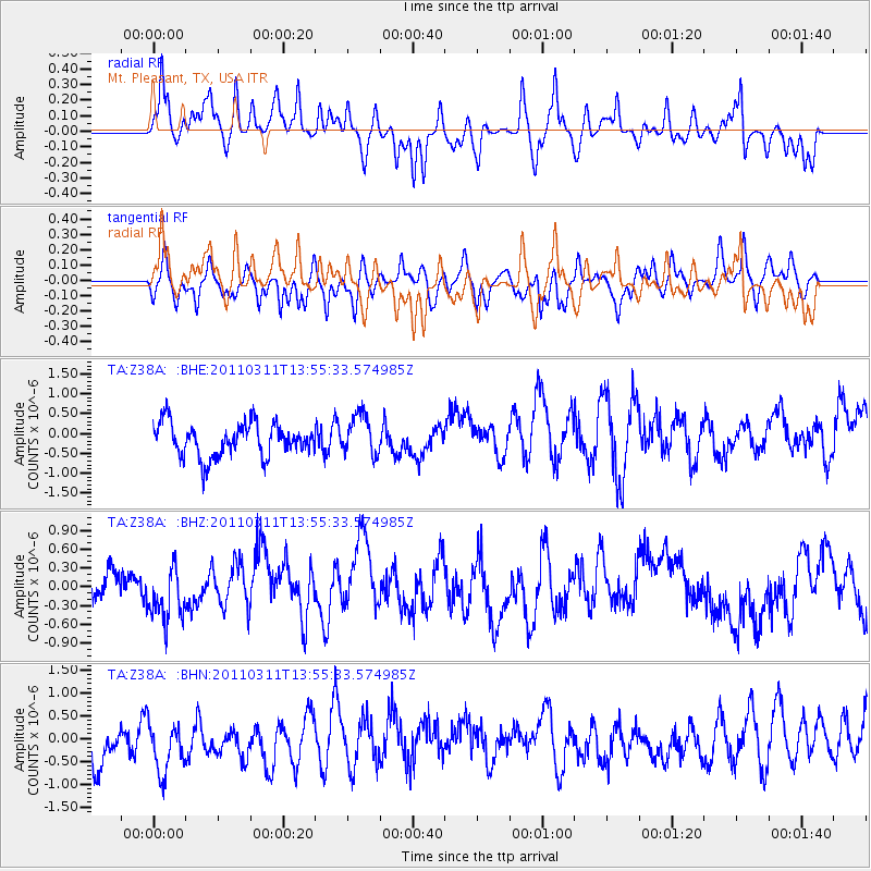
Z38A Mt. Pleasant, TX, USA - Earthquake Result Viewer
*The percent match for this event was below the threshold and hence no stack was calculated.
| Earthquake location: |
Off East Coast Of Honshu, Japan |
| Earthquake latitude/longitude: |
39.0/144.1 |
| Earthquake time(UTC): |
2011/03/11 (070) 13:43:09 GMT |
| Earthquake Depth: |
25 km |
| Earthquake Magnitude: |
5.7 MB |
| Earthquake Catalog/Contributor: |
WHDF/NEIC |
|
| Network: |
TA USArray Transportable Network (new EarthScope stations) |
| Station: |
Z38A Mt. Pleasant, TX, USA |
| Lat/Lon: |
33.25 N/94.99 W |
| Elevation: |
116 m |
|
| Distance: |
89.6 deg |
| Az: |
45.983 deg |
| Baz: |
318.025 deg |
| Ray Param: |
$rayparam |
*The percent match for this event was below the threshold and hence was not used in the summary stack. |
|
| Radial Match: |
48.098557 % |
| Radial Bump: |
359 |
| Transverse Match: |
46.337944 % |
| Transverse Bump: |
345 |
| SOD ConfigId: |
356183 |
| Insert Time: |
2011-08-16 17:08:10.531 +0000 |
| GWidth: |
2.5 |
| Max Bumps: |
400 |
| Tol: |
0.001 |
|
Signal To Noise
| Channel | StoN | STA | LTA |
| TA:Z38A: :BHZ:20110311T13:55:33.574985Z | 0.9416745 | 3.7091556E-7 | 3.9388937E-7 |
| TA:Z38A: :BHN:20110311T13:55:33.574985Z | 1.1581142 | 8.004712E-7 | 6.9118505E-7 |
| TA:Z38A: :BHE:20110311T13:55:33.574985Z | 1.2128551 | 5.1453884E-7 | 4.2423773E-7 |
| Arrivals |
| Ps | |
| PpPs | |
| PsPs/PpSs | |


