You are here: Home > Network List > TA - USArray Transportable Network (new EarthScope stations) Stations List
> Station Y38A Idabel, OK, USA > Earthquake Result Viewer
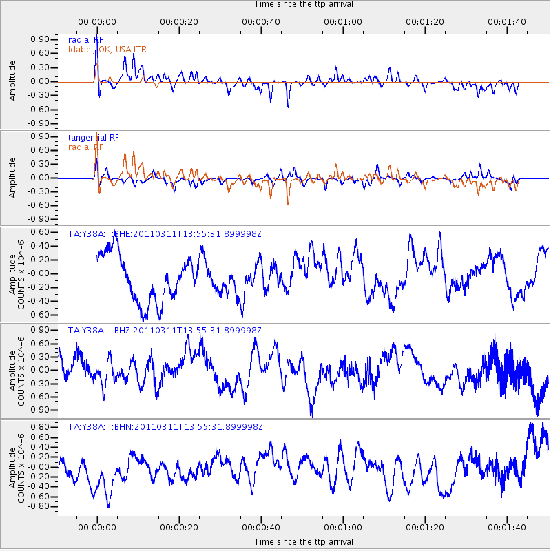
Y38A Idabel, OK, USA - Earthquake Result Viewer
*The percent match for this event was below the threshold and hence no stack was calculated.
| Earthquake location: |
Off East Coast Of Honshu, Japan |
| Earthquake latitude/longitude: |
39.0/144.1 |
| Earthquake time(UTC): |
2011/03/11 (070) 13:43:09 GMT |
| Earthquake Depth: |
25 km |
| Earthquake Magnitude: |
5.7 MB |
| Earthquake Catalog/Contributor: |
WHDF/NEIC |
|
| Network: |
TA USArray Transportable Network (new EarthScope stations) |
| Station: |
Y38A Idabel, OK, USA |
| Lat/Lon: |
33.93 N/94.73 W |
| Elevation: |
118 m |
|
| Distance: |
89.3 deg |
| Az: |
45.373 deg |
| Baz: |
318.159 deg |
| Ray Param: |
$rayparam |
*The percent match for this event was below the threshold and hence was not used in the summary stack. |
|
| Radial Match: |
54.582603 % |
| Radial Bump: |
371 |
| Transverse Match: |
60.187664 % |
| Transverse Bump: |
295 |
| SOD ConfigId: |
356183 |
| Insert Time: |
2011-08-16 17:09:53.625 +0000 |
| GWidth: |
2.5 |
| Max Bumps: |
400 |
| Tol: |
0.001 |
|
Signal To Noise
| Channel | StoN | STA | LTA |
| TA:Y38A: :BHZ:20110311T13:55:31.899998Z | 0.7989252 | 2.797615E-7 | 3.5017231E-7 |
| TA:Y38A: :BHN:20110311T13:55:31.899998Z | 1.6415471 | 8.207878E-7 | 5.000087E-7 |
| TA:Y38A: :BHE:20110311T13:55:31.899998Z | 0.5527061 | 1.8630044E-7 | 3.370696E-7 |
| Arrivals |
| Ps | |
| PpPs | |
| PsPs/PpSs | |


