You are here: Home > Network List > TA - USArray Transportable Network (new EarthScope stations) Stations List
> Station V38A Canehill, AR, USA > Earthquake Result Viewer
V38A Canehill, AR, USA - Earthquake Result Viewer
*The percent match for this event was below the threshold and hence no stack was calculated.
| Earthquake location: |
Off East Coast Of Honshu, Japan |
| Earthquake latitude/longitude: |
39.0/144.1 |
| Earthquake time(UTC): |
2011/03/11 (070) 13:43:09 GMT |
| Earthquake Depth: |
25 km |
| Earthquake Magnitude: |
5.7 MB |
| Earthquake Catalog/Contributor: |
WHDF/NEIC |
|
| Network: |
TA USArray Transportable Network (new EarthScope stations) |
| Station: |
V38A Canehill, AR, USA |
| Lat/Lon: |
35.86 N/94.41 W |
| Elevation: |
372 m |
|
| Distance: |
88.0 deg |
| Az: |
43.889 deg |
| Baz: |
318.307 deg |
| Ray Param: |
$rayparam |
*The percent match for this event was below the threshold and hence was not used in the summary stack. |
|
| Radial Match: |
65.909775 % |
| Radial Bump: |
400 |
| Transverse Match: |
55.441505 % |
| Transverse Bump: |
349 |
| SOD ConfigId: |
356183 |
| Insert Time: |
2011-08-16 17:14:44.964 +0000 |
| GWidth: |
2.5 |
| Max Bumps: |
400 |
| Tol: |
0.001 |
|
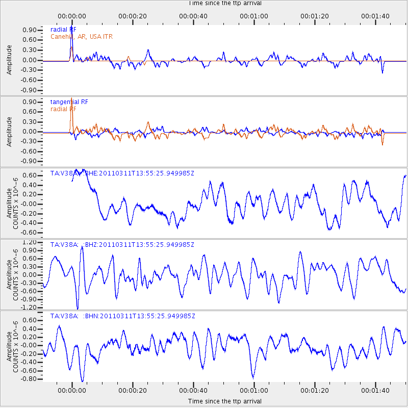
Signal To Noise
| Channel | StoN | STA | LTA |
| TA:V38A: :BHZ:20110311T13:55:25.949985Z | 1.7155086 | 6.409352E-7 | 3.7361235E-7 |
| TA:V38A: :BHN:20110311T13:55:25.949985Z | 2.6832569 | 5.9402254E-7 | 2.2138117E-7 |
| TA:V38A: :BHE:20110311T13:55:25.949985Z | 1.1089357 | 3.8363427E-7 | 3.459482E-7 |
| Arrivals |
| Ps | |
| PpPs | |
| PsPs/PpSs | |


