You are here: Home > Network List > TA - USArray Transportable Network (new EarthScope stations) Stations List
> Station J35A Milford, IA, USA > Earthquake Result Viewer
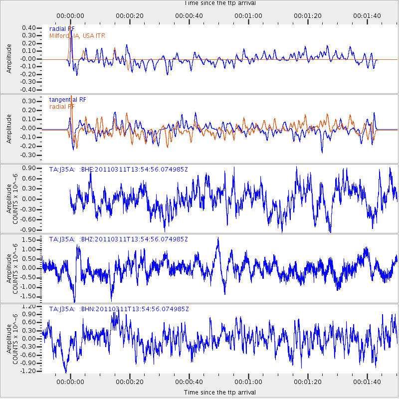
J35A Milford, IA, USA - Earthquake Result Viewer
*The percent match for this event was below the threshold and hence no stack was calculated.
| Earthquake location: |
Off East Coast Of Honshu, Japan |
| Earthquake latitude/longitude: |
39.0/144.1 |
| Earthquake time(UTC): |
2011/03/11 (070) 13:43:09 GMT |
| Earthquake Depth: |
25 km |
| Earthquake Magnitude: |
5.7 MB |
| Earthquake Catalog/Contributor: |
WHDF/NEIC |
|
| Network: |
TA USArray Transportable Network (new EarthScope stations) |
| Station: |
J35A Milford, IA, USA |
| Lat/Lon: |
43.37 N/95.21 W |
| Elevation: |
457 m |
|
| Distance: |
82.0 deg |
| Az: |
39.304 deg |
| Baz: |
317.398 deg |
| Ray Param: |
$rayparam |
*The percent match for this event was below the threshold and hence was not used in the summary stack. |
|
| Radial Match: |
52.48463 % |
| Radial Bump: |
400 |
| Transverse Match: |
50.906673 % |
| Transverse Bump: |
400 |
| SOD ConfigId: |
356183 |
| Insert Time: |
2011-08-16 17:17:55.489 +0000 |
| GWidth: |
2.5 |
| Max Bumps: |
400 |
| Tol: |
0.001 |
|
Signal To Noise
| Channel | StoN | STA | LTA |
| TA:J35A: :BHZ:20110311T13:54:56.074985Z | 1.5932357 | 8.730623E-7 | 5.479806E-7 |
| TA:J35A: :BHN:20110311T13:54:56.074985Z | 1.5465962 | 4.4344515E-7 | 2.867233E-7 |
| TA:J35A: :BHE:20110311T13:54:56.074985Z | 1.7394077 | 4.2567234E-7 | 2.4472257E-7 |
| Arrivals |
| Ps | |
| PpPs | |
| PsPs/PpSs | |


