You are here: Home > Network List > TA - USArray Transportable Network (new EarthScope stations) Stations List
> Station C33A Trail, MN, USA > Earthquake Result Viewer
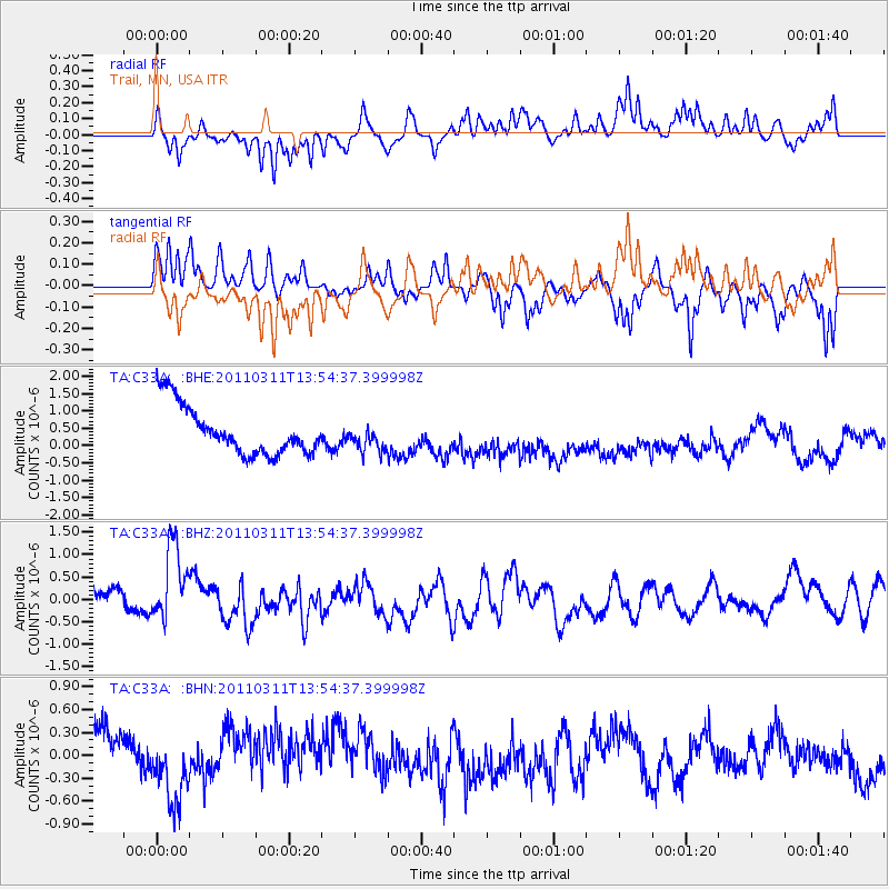
C33A Trail, MN, USA - Earthquake Result Viewer
*The percent match for this event was below the threshold and hence no stack was calculated.
| Earthquake location: |
Off East Coast Of Honshu, Japan |
| Earthquake latitude/longitude: |
39.0/144.1 |
| Earthquake time(UTC): |
2011/03/11 (070) 13:43:09 GMT |
| Earthquake Depth: |
25 km |
| Earthquake Magnitude: |
5.7 MB |
| Earthquake Catalog/Contributor: |
WHDF/NEIC |
|
| Network: |
TA USArray Transportable Network (new EarthScope stations) |
| Station: |
C33A Trail, MN, USA |
| Lat/Lon: |
47.76 N/95.77 W |
| Elevation: |
388 m |
|
| Distance: |
78.5 deg |
| Az: |
36.557 deg |
| Baz: |
316.532 deg |
| Ray Param: |
$rayparam |
*The percent match for this event was below the threshold and hence was not used in the summary stack. |
|
| Radial Match: |
41.405758 % |
| Radial Bump: |
284 |
| Transverse Match: |
45.10655 % |
| Transverse Bump: |
330 |
| SOD ConfigId: |
356183 |
| Insert Time: |
2011-08-16 17:24:23.760 +0000 |
| GWidth: |
2.5 |
| Max Bumps: |
400 |
| Tol: |
0.001 |
|
Signal To Noise
| Channel | StoN | STA | LTA |
| TA:C33A: :BHZ:20110311T13:54:37.399998Z | 2.6855197 | 8.309348E-7 | 3.0941305E-7 |
| TA:C33A: :BHN:20110311T13:54:37.399998Z | 0.9211064 | 3.416992E-7 | 3.7096606E-7 |
| TA:C33A: :BHE:20110311T13:54:37.399998Z | 0.5602576 | 3.904247E-7 | 6.968664E-7 |
| Arrivals |
| Ps | |
| PpPs | |
| PsPs/PpSs | |


