You are here: Home > Network List > TA - USArray Transportable Network (new EarthScope stations) Stations List
> Station C36A Pine Crest Fram, Angora, MN, USA > Earthquake Result Viewer
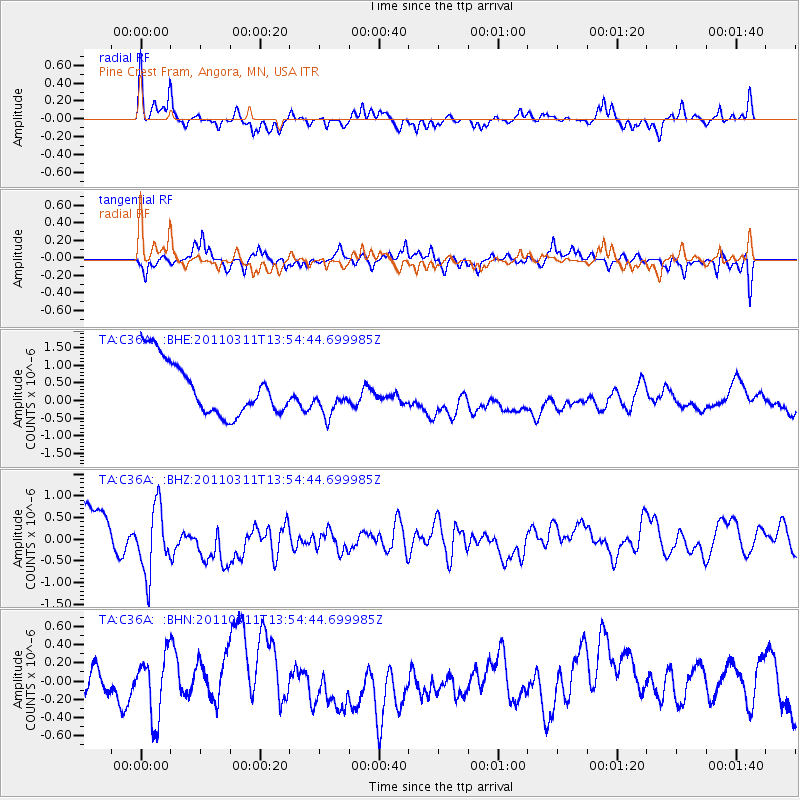
C36A Pine Crest Fram, Angora, MN, USA - Earthquake Result Viewer
*The percent match for this event was below the threshold and hence no stack was calculated.
| Earthquake location: |
Off East Coast Of Honshu, Japan |
| Earthquake latitude/longitude: |
39.0/144.1 |
| Earthquake time(UTC): |
2011/03/11 (070) 13:43:09 GMT |
| Earthquake Depth: |
25 km |
| Earthquake Magnitude: |
5.7 MB |
| Earthquake Catalog/Contributor: |
WHDF/NEIC |
|
| Network: |
TA USArray Transportable Network (new EarthScope stations) |
| Station: |
C36A Pine Crest Fram, Angora, MN, USA |
| Lat/Lon: |
47.76 N/92.84 W |
| Elevation: |
410 m |
|
| Distance: |
79.9 deg |
| Az: |
35.071 deg |
| Baz: |
318.42 deg |
| Ray Param: |
$rayparam |
*The percent match for this event was below the threshold and hence was not used in the summary stack. |
|
| Radial Match: |
63.492687 % |
| Radial Bump: |
313 |
| Transverse Match: |
41.402798 % |
| Transverse Bump: |
300 |
| SOD ConfigId: |
356183 |
| Insert Time: |
2011-08-16 17:30:37.143 +0000 |
| GWidth: |
2.5 |
| Max Bumps: |
400 |
| Tol: |
0.001 |
|
Signal To Noise
| Channel | StoN | STA | LTA |
| TA:C36A: :BHZ:20110311T13:54:44.699985Z | 1.88927 | 8.4908703E-7 | 4.4942598E-7 |
| TA:C36A: :BHN:20110311T13:54:44.699985Z | 1.117943 | 3.8475838E-7 | 3.4416638E-7 |
| TA:C36A: :BHE:20110311T13:54:44.699985Z | 0.7066573 | 5.3703525E-7 | 7.5996564E-7 |
| Arrivals |
| Ps | |
| PpPs | |
| PsPs/PpSs | |


