You are here: Home > Network List > TA - USArray Transportable Network (new EarthScope stations) Stations List
> Station B33A Robert and Kassanda Mosher, Grygla, MN, USA > Earthquake Result Viewer
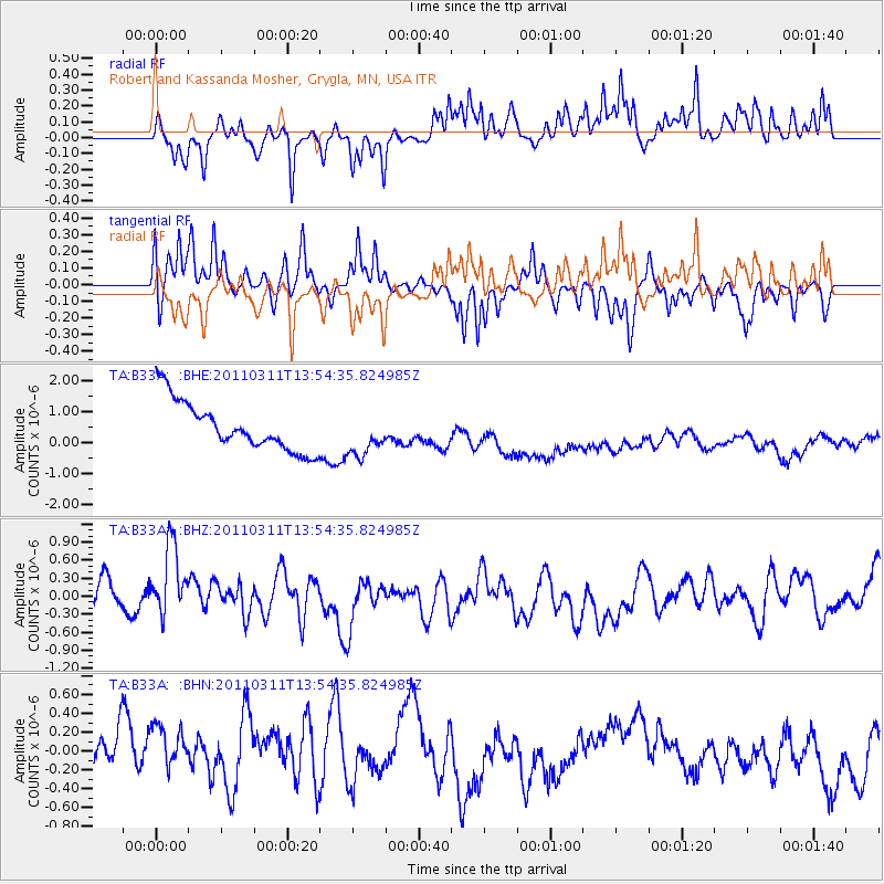
B33A Robert and Kassanda Mosher, Grygla, MN, USA - Earthquake Result Viewer
*The percent match for this event was below the threshold and hence no stack was calculated.
| Earthquake location: |
Off East Coast Of Honshu, Japan |
| Earthquake latitude/longitude: |
39.0/144.1 |
| Earthquake time(UTC): |
2011/03/11 (070) 13:43:09 GMT |
| Earthquake Depth: |
25 km |
| Earthquake Magnitude: |
5.7 MB |
| Earthquake Catalog/Contributor: |
WHDF/NEIC |
|
| Network: |
TA USArray Transportable Network (new EarthScope stations) |
| Station: |
B33A Robert and Kassanda Mosher, Grygla, MN, USA |
| Lat/Lon: |
48.27 N/95.59 W |
| Elevation: |
362 m |
|
| Distance: |
78.2 deg |
| Az: |
36.104 deg |
| Baz: |
316.577 deg |
| Ray Param: |
$rayparam |
*The percent match for this event was below the threshold and hence was not used in the summary stack. |
|
| Radial Match: |
40.58178 % |
| Radial Bump: |
261 |
| Transverse Match: |
54.437405 % |
| Transverse Bump: |
306 |
| SOD ConfigId: |
356183 |
| Insert Time: |
2011-08-16 17:36:18.820 +0000 |
| GWidth: |
2.5 |
| Max Bumps: |
400 |
| Tol: |
0.001 |
|
Signal To Noise
| Channel | StoN | STA | LTA |
| TA:B33A: :BHZ:20110311T13:54:35.824985Z | 2.112775 | 5.8299685E-7 | 2.759389E-7 |
| TA:B33A: :BHN:20110311T13:54:35.824985Z | 1.0667858 | 4.347272E-7 | 4.0751124E-7 |
| TA:B33A: :BHE:20110311T13:54:35.824985Z | 0.90271825 | 7.10542E-7 | 7.8711383E-7 |
| Arrivals |
| Ps | |
| PpPs | |
| PsPs/PpSs | |


