You are here: Home > Network List > TW - Broadband Array in Taiwan for Seismology Stations List
> Station VNAS Nansha Is. > Earthquake Result Viewer
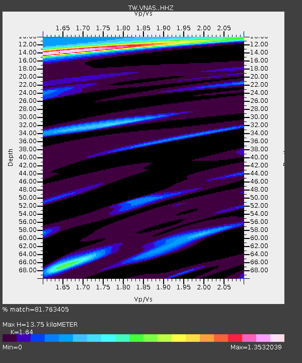
VNAS Nansha Is. - Earthquake Result Viewer
| Earthquake location: |
Xizang |
| Earthquake latitude/longitude: |
35.9/82.6 |
| Earthquake time(UTC): |
2014/02/12 (043) 09:19:49 GMT |
| Earthquake Depth: |
10 km |
| Earthquake Magnitude: |
6.9 MWW, 6.9 MWB, 6.9 MWC |
| Earthquake Catalog/Contributor: |
NEIC PDE/NEIC COMCAT |
|
| Network: |
TW Broadband Array in Taiwan for Seismology |
| Station: |
VNAS Nansha Is. |
| Lat/Lon: |
10.38 N/114.36 E |
| Elevation: |
2.0 m |
|
| Distance: |
38.4 deg |
| Az: |
123.506 deg |
| Baz: |
316.524 deg |
| Ray Param: |
0.07557328 |
| Estimated Moho Depth: |
13.75 km |
| Estimated Crust Vp/Vs: |
1.64 |
| Assumed Crust Vp: |
6.183 km/s |
| Estimated Crust Vs: |
3.77 km/s |
| Estimated Crust Poisson's Ratio: |
0.20 |
|
| Radial Match: |
81.763405 % |
| Radial Bump: |
310 |
| Transverse Match: |
69.74393 % |
| Transverse Bump: |
400 |
| SOD ConfigId: |
3390531 |
| Insert Time: |
2019-04-10 08:00:25.914 +0000 |
| GWidth: |
2.5 |
| Max Bumps: |
400 |
| Tol: |
0.001 |
|

Signal To Noise
| Channel | StoN | STA | LTA |
| TW:VNAS: :HHZ:20140212T09:26:39.989993Z | 2.242286 | 2.0060156E-6 | 8.946297E-7 |
| TW:VNAS: :HHN:20140212T09:26:39.989993Z | 1.0236053 | 1.2185176E-6 | 1.1904175E-6 |
| TW:VNAS: :HHE:20140212T09:26:39.989993Z | 1.8941554 | 1.4371753E-6 | 7.5874203E-7 |
| Arrivals |
| Ps | 1.5 SECOND |
| PpPs | 5.5 SECOND |
| PsPs/PpSs | 7.0 SECOND |


