You are here: Home > Network List > XJ13 - CRAFTI Stations List
> Station LN16 Kitarini PS > Earthquake Result Viewer
LN16 Kitarini PS - Earthquake Result Viewer
| Earthquake location: |
Xizang |
| Earthquake latitude/longitude: |
35.9/82.6 |
| Earthquake time(UTC): |
2014/02/12 (043) 09:19:49 GMT |
| Earthquake Depth: |
10 km |
| Earthquake Magnitude: |
6.9 MWW, 6.9 MWB, 6.9 MWC |
| Earthquake Catalog/Contributor: |
NEIC PDE/NEIC COMCAT |
|
| Network: |
XJ CRAFTI |
| Station: |
LN16 Kitarini PS |
| Lat/Lon: |
2.62 S/36.46 E |
| Elevation: |
1717 m |
|
| Distance: |
57.6 deg |
| Az: |
238.506 deg |
| Baz: |
43.866 deg |
| Ray Param: |
0.06337861 |
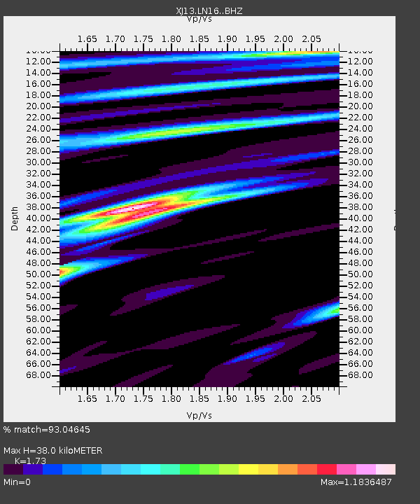
| Estimated Moho Depth: |
38.0 km |
| Estimated Crust Vp/Vs: |
1.73 |
| Assumed Crust Vp: |
6.601 km/s |
| Estimated Crust Vs: |
3.815 km/s |
| Estimated Crust Poisson's Ratio: |
0.25 |
|
| Radial Match: |
93.04645 % |
| Radial Bump: |
381 |
| Transverse Match: |
78.58096 % |
| Transverse Bump: |
400 |
| SOD ConfigId: |
3390531 |
| Insert Time: |
2019-04-10 08:00:52.332 +0000 |
| GWidth: |
2.5 |
| Max Bumps: |
400 |
| Tol: |
0.001 |
|

Signal To Noise
| Channel | StoN | STA | LTA |
| XJ:LN16: :BHZ:20140212T09:29:08.219973Z | 21.634045 | 1.7696874E-6 | 8.180104E-8 |
| XJ:LN16: :BHN:20140212T09:29:08.219973Z | 5.1205106 | 5.942049E-7 | 1.1604406E-7 |
| XJ:LN16: :BHE:20140212T09:29:08.219973Z | 4.572852 | 5.6699497E-7 | 1.2399153E-7 |
| Arrivals |
| Ps | 4.4 SECOND |
| PpPs | 15 SECOND |
| PsPs/PpSs | 19 SECOND |


