You are here: Home > Network List > XJ13 - CRAFTI Stations List
> Station MW42 Engaruka NEW > Earthquake Result Viewer
MW42 Engaruka NEW - Earthquake Result Viewer
| Earthquake location: |
Xizang |
| Earthquake latitude/longitude: |
35.9/82.6 |
| Earthquake time(UTC): |
2014/02/12 (043) 09:19:49 GMT |
| Earthquake Depth: |
10 km |
| Earthquake Magnitude: |
6.9 MWW, 6.9 MWB, 6.9 MWC |
| Earthquake Catalog/Contributor: |
NEIC PDE/NEIC COMCAT |
|
| Network: |
XJ CRAFTI |
| Station: |
MW42 Engaruka NEW |
| Lat/Lon: |
3.04 S/36.10 E |
| Elevation: |
753 m |
|
| Distance: |
58.2 deg |
| Az: |
238.475 deg |
| Baz: |
43.868 deg |
| Ray Param: |
0.06302176 |
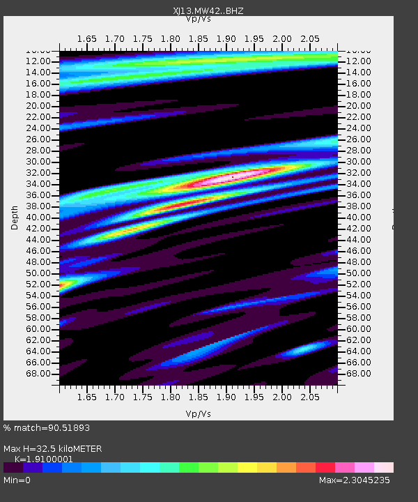
| Estimated Moho Depth: |
32.5 km |
| Estimated Crust Vp/Vs: |
1.91 |
| Assumed Crust Vp: |
6.601 km/s |
| Estimated Crust Vs: |
3.456 km/s |
| Estimated Crust Poisson's Ratio: |
0.31 |
|
| Radial Match: |
90.51893 % |
| Radial Bump: |
400 |
| Transverse Match: |
78.45657 % |
| Transverse Bump: |
400 |
| SOD ConfigId: |
3390531 |
| Insert Time: |
2019-04-10 08:00:57.260 +0000 |
| GWidth: |
2.5 |
| Max Bumps: |
400 |
| Tol: |
0.001 |
|

Signal To Noise
| Channel | StoN | STA | LTA |
| XJ:MW42: :BHZ:20140212T09:29:12.099978Z | 16.815826 | 1.7999535E-6 | 1.0703924E-7 |
| XJ:MW42: :BHN:20140212T09:29:12.099978Z | 5.0983734 | 7.578731E-7 | 1.4864999E-7 |
| XJ:MW42: :BHE:20140212T09:29:12.099978Z | 6.1046896 | 6.7434104E-7 | 1.10462786E-7 |
| Arrivals |
| Ps | 4.7 SECOND |
| PpPs | 14 SECOND |
| PsPs/PpSs | 18 SECOND |


