You are here: Home > Network List > XJ13 - CRAFTI Stations List
> Station PR31 Engaruka Boma > Earthquake Result Viewer
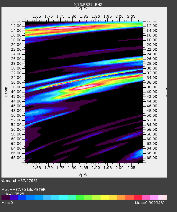
PR31 Engaruka Boma - Earthquake Result Viewer
| Earthquake location: |
Xizang |
| Earthquake latitude/longitude: |
35.9/82.6 |
| Earthquake time(UTC): |
2014/02/12 (043) 09:19:49 GMT |
| Earthquake Depth: |
10 km |
| Earthquake Magnitude: |
6.9 MWW, 6.9 MWB, 6.9 MWC |
| Earthquake Catalog/Contributor: |
NEIC PDE/NEIC COMCAT |
|
| Network: |
XJ CRAFTI |
| Station: |
PR31 Engaruka Boma |
| Lat/Lon: |
2.92 S/36.05 E |
| Elevation: |
884 m |
|
| Distance: |
58.1 deg |
| Az: |
238.618 deg |
| Baz: |
43.946 deg |
| Ray Param: |
0.063054055 |
| Estimated Moho Depth: |
37.75 km |
| Estimated Crust Vp/Vs: |
1.85 |
| Assumed Crust Vp: |
6.601 km/s |
| Estimated Crust Vs: |
3.563 km/s |
| Estimated Crust Poisson's Ratio: |
0.29 |
|
| Radial Match: |
87.47981 % |
| Radial Bump: |
400 |
| Transverse Match: |
72.227615 % |
| Transverse Bump: |
400 |
| SOD ConfigId: |
3390531 |
| Insert Time: |
2019-04-10 08:01:02.105 +0000 |
| GWidth: |
2.5 |
| Max Bumps: |
400 |
| Tol: |
0.001 |
|

Signal To Noise
| Channel | StoN | STA | LTA |
| XJ:PR31: :BHZ:20140212T09:29:11.760012Z | 17.517052 | 1.8265918E-6 | 1.0427507E-7 |
| XJ:PR31: :BHN:20140212T09:29:11.760012Z | 4.601326 | 6.128265E-7 | 1.3318477E-7 |
| XJ:PR31: :BHE:20140212T09:29:11.760012Z | 3.4981847 | 4.6933093E-7 | 1.3416414E-7 |
| Arrivals |
| Ps | 5.1 SECOND |
| PpPs | 16 SECOND |
| PsPs/PpSs | 21 SECOND |


